

Development characteristics and susceptibility assessment of coseismic geological hazards of Jishishan MS 6.2 earthquake, Gansu Province, China
-
摘要: 2023年12月18日,甘肃积石山县发生MS 6.2地震,诱发的同震地质灾害严重威胁到人民生命和财产安全,因此及时总结分析同震地质灾害发育规律并进行县域易发性评价,对支撑震后恢复重建至关重要。通过应急排查、野外调查与结果分析,对同震地质灾害发育特征进行分析总结;以震后排查的同震新增和加剧隐患点为分析样本,采用Pearson相关性系数与随机森林Gini系数分析方法,筛选了15个影响因子,并运用机器学习-随机森林模型对积石山县进行同震地质灾害易发性评价。结果表明,震区同震地质灾害总体发育程度不强,规模以小型为主,崩滑流地质灾害隐患可分为3大类、8个亚类,绝大部分分布在黄土丘陵区;积石山县同震地质灾害随机森林模型易发性评价(AUC=0.961)结果显示,极高易发区面积占比约8.67%,主要分布在胡林家乡、徐扈家乡、柳沟乡等乡镇,且县域及各乡镇易发性分级结构与隐患点密度分布吻合程度高。评价结果对已有排查隐患点以外的震裂山体或潜在崩滑流灾害具有重要指示作用,可为积石山县灾后恢复重建规划提供决策支撑,同时将Pearson相关性系数与随机森林Gini系数的影响因子筛选方法及机器学习模型——随机森林应用于易发性评价中,可为其他山地丘陵区地质灾害易发性评价提供参考。Abstract:
Objective On December 18, 2023, an MS 6.2 earthquake occurred in Jishishan County, Gansu Province, China. Coseismic geological hazards induced by the earthquake crucially threatened the safety of personnel and property. Existing research is mainly concentrated in the vicinity of active faults and the concentrated distribution area of hidden danger points. Moreover, no special susceptibility assessment studies have been carried out on coseismic geological hazards in the administrative area of Jishishan County, making it challenging to meet the needs of the county's post-disaster recovery and reconstruction planning. Hence, the development laws of coseismic geological hazards must be summarized and analyzed crucially, and county susceptibility must be analyzed in time to support post-earthquake recovery and reconstruction. Methods The development characteristics of coseismic geological hazards are analyzed and summarized through emergency investigations, field surveys, and result analysis. Using the newly added and exacerbated coseismic hazard points identified during post-earthquake investigations as analysis samples, influencing factors were selected using the Pearson correlation coefficient and random forest Gini coefficient analysis methods. Then, a machine learning-random forest model was applied to assess the susceptibility of coseismic geological hazards in Jishishan County. Results In analyzing the development characteristics of coseismic geological hazards, we identified 134 instances of increased and exacerbated hazards in Jishishan County. Overall, the degree of development of these hazards was relatively low, with primarily small-scale occurrences. These hazards were categorized into three main types and eight sub-categories: ① Collapse (including cut slope loess collapse, high loess collapse, and high rock collapse); ② Landslide (encompassing loess landslide, secondary sand/mudstone landslide, and potential landslide); and ③ Debris flow (comprising gully debris flow and slope debris flow). In terms of factor selection, 15 influencing factors were screened. Regarding the susceptibility assessment results, the AUC value of the susceptibility assessment results of coseismic geological hazards in most Jishishan counties was 0.961, and the results showed that the areas of extremely high susceptibility accounted for approximately 8.67 %, mainly distributed in Hulinjia, Xuhujia, Liugoujia, and other townships. The statistical results of the proportion of susceptibility zones in 17 townships in Jishishan County showed that the top three townships with the largest proportions of extremely high-susceptibility areas are Hulinjia (24.67%), Xuhujia (21.24%), and Biezang (20.94%). Conclusion (1) Most coseismic geological hazards in Jishishan are distributed in the loess hilly area, with few occurrences in the Jishishan area and the right bank terrace of the Yellow River. (2) The influence of elevation and peak ground acceleration (PGA) on hazard occurrence is notably greater than that of other factors, playing a predominant role in developing coseismic geological hazards. (3) Utilizing the random forest model, the susceptibility assessment of coseismic geological hazards in Jishishan County demonstrates high accuracy, with hidden danger points clustered in highly susceptible areas. This alignment between susceptibility assessment results and the spatial distribution of hidden dangers underscores the reliability of the assessment outcomes. Significance In addition to identifying existing hidden danger points, this study offers predictive insights into slope deformation and potential landslides significantly affected by seismic cracking. The assessment results exhibit high accuracy and reliability, offering valuable geological safety support for post-disaster recovery and reconstruction planning in the county. -
Key words:
- Jishishan earthquake /
- coseismic /
- geological hazards /
- susceptibility /
- random forest /
- influencing factor
-

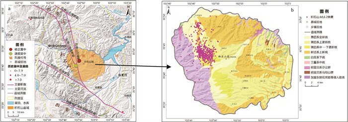
图 1 积石山县区域地质背景图(图件要素数据来源:活动断裂据震区活动断裂野外调查编绘;速报震中及余震数据来源:国家地震科学数据中心
https://data.earthquake.cn/datashare ;修正震中数据来源:房立华等,2023)a—积石山区域概况与震中位置;b—积石山地层分区与余震分布
Figure 1. Regional geological background map of Jishishan County; Source of map elements: active faults from field survey mapping of active faults in the seismic area; rapidly reported epicenter and aftershocks from National Earthquake Science Data Center
https://data.earthquake.cn/datashare ); correction of the epicenter from Fang et al., 2023(a) Overview of Jishishan area and epicenter location; (b) Stratigraphic division and aftershock distribution in the Jishishan area

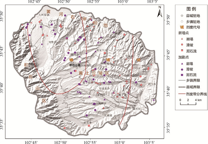
图 2 积石山县各乡镇同震地质灾害分布图
Figure 2. Distribution map of coseismic geological hazards in each township of Jishishan County

图 3 积石山县17个乡镇同震地质灾害统计图(隐患点数量由高到低)
Figure 3. Statistical chart of coseismic geological hazards in 17 townships of Jishishan County (number of hidden danger points from high to low)

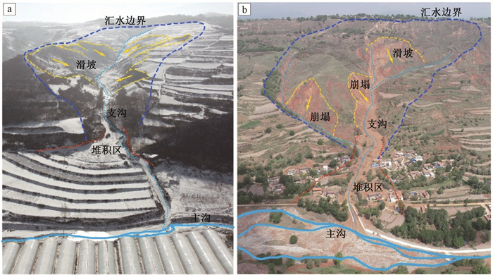
图 4 震区典型崩塌
a—切坡建房黄土崩塌(镜向东);b—切坡修路黄土崩塌(镜向北东);c—高位黄土崩塌左侧边界(镜向南西);d—高位黄土崩塌典型危岩体(镜向西);e—典型高位黄土崩塌全貌(镜向北西);f—高位岩质崩塌碎屑流(镜向西);g—高位岩质崩塌崩积物(镜向北东);h—高位岩质崩塌危岩体(镜向北东)
Figure 4. Photos of typical collapses in the seismic zone
(a) Loess collapse of house built on cut-slope (oriented towards east); (b) Loess collapse of road built on cut-slope (oriented towards northeast); (c) Left boundary of high-position loess collapse (oriented towards southwest); (d) Typical dangerous rock mass of high-position loess collapse (oriented towards west); (e) Overall view of typical high-position loess collapse (oriented towards northwest); (f) Debris flow of high-position rocky collapse (oriented towards west); (g) Debris of high-position rocky collapse (oriented towards northeast); (h) Dangerous rock mass of high-position rocky collapse (oriented towards northeast)

图 5 震区典型滑坡
a—黄土滑坡全貌(镜向北东);b—下伏泥岩黄土滑坡(镜向南西);c—砂泥岩滑坡全貌(镜向北东);d—砂泥岩滑坡次级滑体(镜向北东);e—潜在滑坡右侧变形特征(镜向南西);f—潜在滑坡左侧变形特征(镜向北东);g—潜在滑坡边界俯视全貌
Figure 5. Photos of typical landslides in the seismic zone
(a) Loess landslide overview (oriented towards the northeast); (b) Loess landslide lying on mudstone (oriented towards the southwest); (c) Sand-mudstone landslide overview (oriented towards the northeast); (d) Secondary sliding body of sand-mudstone landslide (oriented towards the northeast); (e) Deformation features on the right side of potential landslide (oriented towards the southwest); (f) Deformation features on the left side of potential landslide (oriented towards the northeast); (g) Aerial view of the boundary of potential landslide

图 6 震区典型泥石流
a—沟谷型泥石流(镜向南);b—坡面型泥石流(镜向北西)
Figure 6. Photos of typical debris flows in the seismic zone
(a) Gully-type debris flow (oriented towards the south); (b) Slope-type debris flow (oriented towards the northwest)

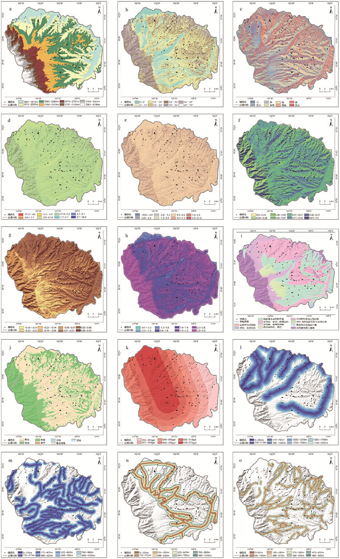
图 10 各因子与同震地质灾害分布图
a—高程与同震灾害分布图;b—坡度与同震灾害分布图;c—坡向与同震灾害分布图;d—平面曲率与同震灾害分布图;e—剖面曲率与同震灾害分布图;f—归一化植被指数(NDVI)与同震灾害分布图;g—归一化建筑指数(NDBI)与同震灾害分布图;h—水体指数(SPI)与同震灾害分布图;i—地层岩性与同震灾害分布图;j—土地利用类型与同震灾害分布图;k—地震动峰值加速度(PGA)与同震灾害分布图;l—距一级河流距离与同震灾害分布图;m—距二级河流距离与同震灾害分布图;n—距一级道路距离与同震灾害分布图;o—距二级道路距离与同震灾害分布图
Figure 10. Distribution of each factor and coseismic geological hazards
(a) Elevation and distribution of coseismic hazards; (b) Slope and distribution of coseismic hazards; (c) Aspect and distribution of coseismic hazards; (d) Plan curvature and distribution of coseismic hazards; (e) Profile curvature and distribution of coseismic hazards; (f) NDVI and distribution of coseismic hazards; (g) NDBI and distribution of coseismic hazards; (h) SPI and distribution of coseismic hazards; (i) Stratigraphic lithology and distribution of coseismic hazards; (j) Land-use type and distribution of coseismic hazards; (k) PGA and distribution of coseismic hazards; (l) Distance from the primary rivers and distribution of coseismic hazards; (m) Distance from secondary rivers and distribution of coseismic hazards; (n) Distance from primary roads and distribution of coseismic hazards; (o) Distance from secondary roads and distribution of coseismic hazards

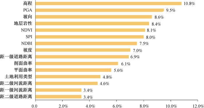
图 11 各因子与同震灾害分布统计图
a—高程与同震灾害分布统计图;b—坡度与同震灾害分布统计图;c—坡向与同震灾害分布统计图;d—平面曲率与同震灾害分布统计图;e—剖面曲率与同震灾害分布统计图;f—归一化植被指数(NDVI)与同震灾害分布统计图;g—归一化建筑指数(NDBI)与同震灾害分布统计图;h—水体指数(SPI)与同震灾害分布统计图;i—地层岩性与同震灾害分布统计图;j—土地利用类型与同震灾害分布统计图;k—地震动峰值加速度(PGA)与同震灾害分布统计图;l—距一级河流距离与同震灾害分布统计图;m—距二级河流距离与同震灾害分布统计图;n—距一级道路距离与同震灾害分布统计图;o—距二级道路距离与同震灾害分布统计图
Figure 11. Distribution of each factor and coseismic hazards
(a) Elevation and distribution of coseismic hazard statistics; (b) Slope and distribution of coseismic hazard statistics; (c) Aspect and distribution of coseismic hazard statistics; (d) Plan curvature and distribution of coseismic hazard statistics; (e) Profile curvature and distribution of coseismic hazard statistics; (f) NDVI and distribution of coseismic hazard statistics; (g) NDBI and distribution of coseismic hazard statistics; (h) SPI and distribution of coseismic hazard statistics; (i) Stratigraphic lithology and distribution of coseismic hazard statistics; (j) Land-use type and distribution of coseismic hazard statistics; (k) PGA and distribution of coseismic hazard statistics; (l) Distance from primary rivers and distribution of coseismic hazard statistics; (m) Distance from secondary rivers and distribution of coseismic hazard statistics; (n) Distance from primary roads and distribution of coseismic hazard statistics; (o) Distance from secondary roads and distribution of coseismic hazard statistics

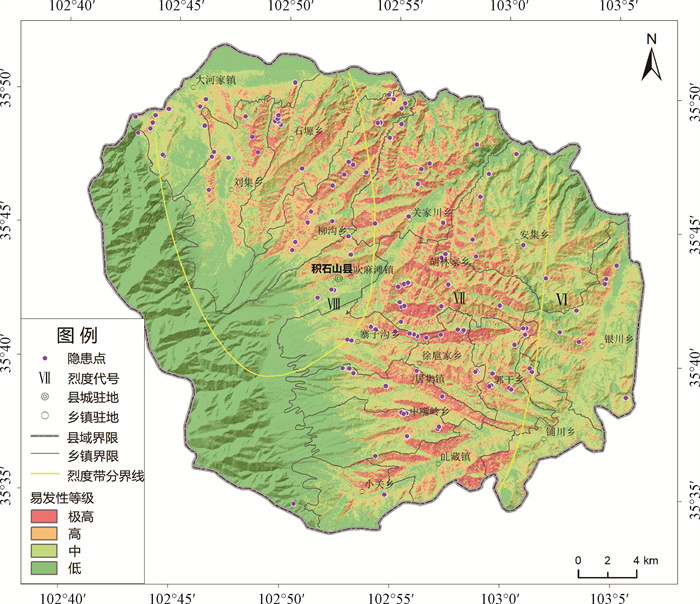
图 13 积石山县同震地质灾害易发性评价结果图
Figure 13. Seismic geological hazard susceptibility assessment results of Jishishan County

图 14 积石山县易发性评价结果ROC曲线
Figure 14. ROC curve of susceptibility assessment results in Jishishan County

图 15 积石山县不同易发性等级面积占比与隐患点数量占比及密度统计图
Figure 15. Statistical chart of area proportion of different susceptibility levels, number proportion of hidden danger points, and density in Jishishan County

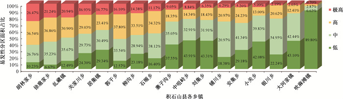
图 16 积石山县各乡镇易发性分区面积占比统计图(极高易发区面积占比由高到低)
Figure 16. Statistical map of the proportion of susceptibility areas in Jishishan County (Proportion of extremely high susceptibility areas is from high to low)
表 1 初选影响因子数据来源说明表
Table 1. Data source for initial influence factors
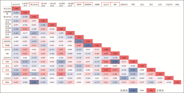
序号 分类 要素 致灾指示意义、数据说明及处理方法 1~6 地形地貌 坡度、坡向、高程、平面曲率、剖面曲率、起伏度 指示坡体几何形态属性,基于ALOS DEM(12.5 m分辨率) 7 地层岩性 地层岩性分区 指示斜坡岩土体的物理力学强度特征,基于1∶20万地质图(公开版) 8~9 河流 距一级河流距离、距二级河流距离 指示坡脚侵蚀及坡体的水文地质特征,使用1∶25万基础地理信息数据 10~11 道路 距一级道路距离、距二级道路距离 指示人类工程活动对斜坡破环的影响,使用1∶25万基础地理信息数据 12 地震 地震动峰值加速度(PGA) 指示地震震动效应对斜坡破坏的影响,基于实测地震烈度台站记录,采用考虑断层距的地震动峰值加速度经验衰减关系(肖亮,2012)拟合计算生成,1 km栅格 13 地质构造 距断层距离 指示地质体结构破碎及对地质灾害发育的影响,基于震区活动断裂野外调查编测 14~15 环境地质特征 水流强度指数(SPI)、地形湿度指数(TWI) 指示影响斜坡发育的水文环境地质特征,基于ALOS DEM(12.5 m分辨率)栅格计算生成 16 修正归一化水体指数(MNDWI) 指示影响斜坡发育的水文环境地质特征,基于landsat8遥感影响数据,30 m分辨率 17~18 土地利用类型、归一化建筑指数(NDBI) 指示影响斜坡发育的人类活动环境地质特征,基于landsat8遥感影响数据,30 m分辨率 19 归一化植被指数(NDVI) 指示影响斜坡发育的自然环境地质特征,基于landsat8遥感影响数据,30 m分辨率  下载: 导出CSV
-
ABBAS F, ZHANG F, ISMAIL M, et al., 2023. Optimizing machine learning algorithms for landslide susceptibility mapping along the Karakoram highway, Gilgit Baltistan, Pakistan: a comparative study of baseline, Bayesian, and metaheuristic Hyperparameter optimization techniques[J]. Sensors, 23(15): 6843. doi: 10.3390/s23156843 ACHU A L, AJU C D, DI NAPOLI M, et al., 2023. Machine-learning based landslide susceptibility modelling with emphasis on uncertainty analysis[J]. Geoscience Frontiers, 14(6): 101657. doi: 10.1016/j.gsf.2023.101657 ADO M, AMITAB K, MAJI A K, et al., 2022. Landslide susceptibility mapping using machine learning: a literature survey[J]. Remote Sensing, 14(13): 3029. doi: 10.3390/rs14133029 CANTARINO I, CARRION M A, GOERLICH F, et al., 2019. A ROC analysis-based classification method for landslide susceptibility maps[J]. Landslides, 16(2): 265-282. doi: 10.1007/s10346-018-1063-4 CHEN B, SONG C, CHEN Y, et al., 2024. Emergency Identification and Influencing Factor Analysis of Coseismic Landslides and Building Damages Induced by the 2023 MS6.2 Jishishan (Gansu, China) Earthquake[J/OL]. Geomatics and Information Science of Wuhan University, 1-16. https://doi.org/10.13203/J.whugis20230497 , 2024-01-17. (in Chinese with English abstract)Danika S, Edward M, Sylvia H M, 2019. A Mixed-Methods Evaluation of a Gender Affirmative Education Program for Families of Trans Young People[J]. Journal of GLBT Family Studies, 16(1). DE OLIVEIRA G G, RUIZ L F C, GUASSELLI L A, et al., 2019. Random forest and artificial neural networks in landslide susceptibility modeling: a case study of the Fão River Basin, Southern Brazil[J]. Natural Hazards, 99(2): 1049-1073. doi: 10.1007/s11069-019-03795-x FAN W, WEI X S, CAO Y B, et al., 2017. Landslide susceptibility assessment using the certainty factor and analytic hierarchy process[J]. Journal of Mountain Science, 14(5): 906-925. doi: 10.1007/s11629-016-4068-2 FANG L H, YANG T, FAN L P, 2023. On December 18, 2023, Jishishan County, Linxia Prefecture, Gansu Province, MS 6.2 earthquake science and technology support briefing[EB/OL]. Geophysical Research Institute of China Seismological Bureau. https://www.cea-igp.ac.cn/kydt/280418.html . (in Chinese)HUANG R Q, LI W L, 2008. Research on development and distribution rules of Geohazards induced by Wenchuan earthquake on 12th May, 2008[J]. Chinese Journal of Rock Mechanics and Engineering, 27(12): 2585-2592. (in Chinese with English abstract) doi: 10.3321/j.issn:1000-6915.2008.12.028 HUANG R Q, LI W L, 2008. "5.12" Wenchuan earthquake triggered the development and distribution of geological disasters [J]. Rock mechanics and engineering, 27 (12): 2585-2592. (in Chinese) doi: 10.3321/j.issn:1000-6915.2008.12.028 LI R, HUANG S Y, DOU H Q, 2023. Dynamic risk assessment of landslide hazard for large-scale photovoltaic power plants under extreme rainfall conditions[J]. Water, 15(15): 2832. doi: 10.3390/w15152832 LI W L, XU Q, LI Y S, et al., 2024. Preliminary analysis of the coseismic geohazards induced by the 2023 Jishishan MS6.2 earthquake[J]. Journal of Chengdu University of Technology (Science & Technology Edition), 51(1): 33-45, 90. (in Chinese with English abstract) LI X, XUE G C, LIU C Z, et al., 2022. Evaluation of Geohazard susceptibility based on information value model and information value-logistic regression model: A case study of the central mountainous area of Hainan Island[J]. Journal of Geomechanics, 28(2): 294-305. (in Chinese with English abstract) LIU J M, WANG T, DU J J, et al., 2023. Emergency rapid assessment of landslides induced by the Luding MS6.8 earthquake in Sichuan of China[J]. Hydrogeology & Engineering Geology, 50(2): 84-94. (in Chinese with English abstract) LIU S, ZHU J Y, YANG D H, et al., 2023. Geological hazard assessment of collapse and landslide under different rainfall conditions[J/OL]. Bulletin of Geological Science and Technology, 1-19. https://doi.org/10.19509/j.cnki.dzkq.tb20220448 , 2024-01-17. (in Chinese with English abstract)SHAREK D, MCCANN E, HUNTLEY-MOORE S, 2020. A mixed-methods evaluation of a gender affirmative education program for families of trans young people[J]. Journal of GLBT Family Studies, 16(1): 18-31. doi: 10.1080/1550428X.2019.1614504 SUN D L, CHEN D L, MI C L, et al., 2023. Evaluation of landslide susceptibility in the gentle hill-valley areas based on the interpretable random forest-recursive feature elimination model[J]. Journal of Geomechanics, 29(2): 202-219. (in Chinese with English abstract) TIE Y B, ZHANG X Z, CAO J W, et al., 2024. Comparative research of the characteristics of geological hazards induced by the Jishishan (MS6.2) and Luding (MS6.8) earthquakes[J]. Journal of Chengdu University of Technology (Science & Technology Edition), 51(1): 9-21, 59. (in Chinese with English abstract) WANG L C, HOU S S, DONG Y, et al., 2023. Basic characteristics of co-seismic geological hazards induced by Jishishan MS6.2 earthquake and suggestions for their risk control[J/OL]. The Chinese Journal of Geological Hazard and Control, 1-11. http://kns.cnki.net/kcms/detail/11.2852.P.20231228.1352.002.html , 2024-01-17. (in Chinese with English abstract)WANG T, MA Y S, LONG C X, et al., 2008. Fault activity of the Wenchuan earthquake in Sichuan, China and seismic secondary geohazards[J]. Geological Bulletin of China, 27(11): 1913-1922. (in Chinese with English abstract) WANG T, WU S R, SHI J S, et al., 2015. Concepts and mechanical assessment method for seismic landslide hazard: a review[J]. Journal of Engineering Geology, 23(1): 93-104. (in Chinese with English abstract) WANG Y S, ZHAO B, JI F, et al., 2024. Preliminary insights into the hazards triggered by the 2023 Jishishan MS6.2 earthquake in Gansu province[J]. Journal of Chengdu University of Technology (Science & Technology Edition), 51(1): 1-8. (in Chinese with English abstract) XIAO L, 2012. Study on the attenuation relationship of strong ground motion parameters of horizontal bedrock [J]. International seismic dynamics, (1): 37-39. (in Chinese with English abstract) XU C, XU X W, 2012. GIS and ANN model for earthquake triggered landslides susceptibility zonation[J]. Geological Science and Technology Information, 31(3): 116-121. (in Chinese with English abstract XU Q, HUANG R Q, 2008. Kinetics charateristics of large landlides triggered by May 12th Wenchuan earthquake[J]. Journal of Engineering Geology, 16(6): 721-729. (in Chinese with English abstract) YANG Z H, LAN H X, ZHANG Y S, et al., 2017. Research review on long-term activity of post-earthquake geohazard in strong seismic-disturbed regions[J]. Journal of Geomechanics, 23(5): 743-753. (in Chinese with English abstract) YIN Y P, ZHANG Y S, WU F Q, et al., 2014. Research achievements and prospects on Wenchuan earthquake-induced Geohazard investigation[J]. Geological Survey of China, 1(1): 1-9. (in Chinese with English abstract) YOUSSEF A M, POURGHASEMI H R, POURTAGHI Z S, et al., 2016. Landslide susceptibility mapping using random forest, boosted regression tree, classification and regression tree, and general linear models and comparison of their performance at Wadi Tayyah Basin, Asir Region, Saudi Arabia[J]. Landslides, 13(5): 839-856. YUAN D Y, 2003. Tectonic deformation features and space-time evolution in northeastern margin of the Qinghai-Tibetan Plateau since the late Cenozoic time[D]. Beijing: Institute of Geology, China Earthquake Administration. (in Chinese with English abstract) YUAN D Y, ZHANG P Z, LEI Z S, et al., 2005. A preliminary study on the new activity features of the Lajishan mountain fault zone in Qinghai Province[J]. Earthquake Research in China, 21(1): 93-102. (in Chinese with English abstract) ZANG B, 2012. The study of new activities on western segment of northern margin of western Qinling fault and Laji Shan fault[D]. Lanzhou: Lanzhou Institute of Seismology, China Earthquake Administration. (in Chinese with English abstract) ZHANG Y S, MA Y S, HU D G, et al., 2010. Investigation and research on the surface rupture of the Yushu earthquake and reconstruction site selection[J]. Acta Geologica Sinica, 84(5): 593-605. (in Chinese with English abstract) 陈博, 宋闯, 陈毅, 等, 2024. 2023年甘肃积石山MS6.2地震同震滑坡和建筑物损毁情况应急识别与影响因素研究[J/OL]. 武汉大学学报(信息科学版), 1-16. https://doi.org/10.13203/J.whugis20230497 , 2024-01-17.房立华, 杨婷, 范莉苹, 2023. 2023年12月18日甘肃临夏州积石山县6.2级地震科技支撑简报[EB/OL]. 中国地震局地球物理研究所. https://www.cea-igp.ac.cn/kydt/280418.html , 2024-01-17.黄润秋, 李为乐, 2008. "5.12"汶川大地震触发地质灾害的发育分布规律研究[J]. 岩石力学与工程学报, 27(12): 2585-2592. https://www.cnki.com.cn/Article/CJFDTOTAL-YSLX200812032.htm 李为乐, 许强, 李雨森, 等, 2024. 2023年积石山MS6.2级地震同震地质灾害初步分析[J]. 成都理工大学学报(自然科学版), 51(1): 33-45, 90. https://www.cnki.com.cn/Article/CJFDTOTAL-CDLG202401004.htm 李信, 薛桂澄, 柳长柱, 等, 2022. 基于信息量模型和信息量-逻辑回归模型的海南岛中部山区地质灾害易发性研究[J]. 地质力学学报, 28(2): 294-305. doi: 10.12090/j.issn.1006-6616.2021111?viewType=HTML 刘甲美, 王涛, 杜建军, 等, 2023. 四川泸定MS6.8级地震诱发崩滑灾害快速评估[J]. 水文地质工程地质, 50(2): 84-94. https://www.cnki.com.cn/Article/CJFDTOTAL-SWDG202302009.htm 刘帅, 朱杰勇, 杨得虎, 等, 2023. 不同降雨工况条件下的崩滑地质灾害危险性评价[J/OL]. 地质科技通报, 1-19. https://doi.org/10.19509/j.cnki.dzkq.tb20220448 , 2024-01-17.孙德亮, 陈丹璐, 密长林, 等, 2023. 基于随机森林-特征递归消除模型的可解释性缓丘岭谷地貌滑坡易发性评价[J]. 地质力学学报, 29(2): 202-219. doi: 10.12090/j.issn.1006-6616.2022128?viewType=HTML 铁永波, 张宪政, 曹佳文, 等, 2024. 积石山MS6.2级和泸定MS6.8级地震地质灾害发育规律对比[J]. 成都理工大学学报(自然科学版), 51(1): 9-21, 59. https://www.cnki.com.cn/Article/CJFDTOTAL-CDLG202401002.htm 王立朝, 侯圣山, 董英, 等, 2023. 甘肃积石山MS6.2级地震的同震地质灾害基本特征及风险防控建议[J/OL]. 中国地质灾害与防治学报, 1-11. http://kns.cnki.net/kcms/detail/11.2852.P.20231228.1352.002.html , 2024-01-17.王涛, 马寅生, 龙长兴, 等, 2008. 四川汶川地震断裂活动和次生地质灾害浅析[J]. 地质通报, 27(11): 1913-1922. https://www.cnki.com.cn/Article/CJFDTOTAL-ZQYD200811025.htm 王涛, 吴树仁, 石菊松, 等, 2015. 地震滑坡危险性概念和基于力学模型的评估方法探讨[J]. 工程地质学报, 23(1): 93-104. https://www.cnki.com.cn/Article/CJFDTOTAL-GCDZ201501019.htm 王运生, 赵波, 吉锋, 等, 2024. 2023年甘肃积石山MS6.2级地震震害异常的启示[J]. 成都理工大学学报(自然科学版), 51(1): 1-8. https://www.cnki.com.cn/Article/CJFDTOTAL-CDLG202401001.htm 肖亮, 2012. 水平向基岩强地面运动参数衰减关系研究[J]. 国际地震动态, (1): 37-39. https://www.cnki.com.cn/Article/CJFDTOTAL-GJZT201201016.htm 许冲, 徐锡伟, 2012. 基于GIS与ANN模型的地震滑坡易发性区划[J]. 地质科技情报, 31(3): 116-121. https://www.cnki.com.cn/Article/CJFDTOTAL-DZKQ201203019.htm 许强, 黄润秋, 2008. 5.12汶川大地震诱发大型崩滑灾害动力特征初探[J]. 工程地质学报, 16(6): 721-729. https://www.cnki.com.cn/Article/CJFDTOTAL-GCDZ200806001.htm 杨志华, 兰恒星, 张永双, 等, 2017. 强震区震后地质灾害长期活动性研究综述[J]. 地质力学学报, 23(5): 743-753. https://journal.geomech.ac.cn/article/id/416fc018-d66f-480e-b56e-55765e72d737?viewType=HTML 殷跃平, 张永双, 伍法权, 等, 2014. 汶川地震地质灾害调查成果与展望[J]. 中国地质调查, 1(1): 1-9. https://www.cnki.com.cn/Article/CJFDTOTAL-DZDC201401002.htm 袁道阳, 2003. 青藏高原东北缘晚新生代以来的构造变形特征与时空演化[D]. 北京: 中国地震局地质研究所. 袁道阳, 张培震, 雷中生, 等, 2005. 青海拉脊山断裂带新活动特征的初步研究[J]. 中国地震, 21(1): 93-102. https://www.cnki.com.cn/Article/CJFDTOTAL-ZGZD200501009.htm 张波, 2012. 西秦岭北缘断裂西段与拉脊山断裂新活动特征研究[D]. 兰州: 中国地震局兰州地震研究所. 张永双, 马寅生, 胡道功, 等, 2010. 玉树地震地表破裂调查与灾后重建避让选址研究[J]. 地质学报, 84(5): 593-605. https://www.cnki.com.cn/Article/CJFDTOTAL-DZXE201005002.htm -

 下载:
下载:


 点击查看大图
计量
- 文章访问数: 136
- HTML全文浏览量: 13
- PDF下载量: 32
- 被引次数: 0
