

Control of bedrock geology on active structural deformation revealed by changes in geomorphic parameters: A case study of the Fodongmiao-Hongyazi Frontal Thrust, NE Tibet
-
摘要: 全球广泛分布的活动断层是孕育地表破裂型强震的天然载体,地球科学观测揭示活动断层的先存几何结构对地震地表破裂的发育演化具有很强的控制作用。目前针对活动断层地表构造变形特征与基岩地质背景关系的研究较少且仅局限于高温高压岩石力学实验尺度,缺乏数百千米尺度天然活动断层结构特征的直接参考,尤其是关于活动逆冲断层的研究相对更少。不断发展的高精度对地观测技术和活动构造定量研究方法能够更加精细地刻画活动断层大尺度几何结构,清晰揭示断层多参数错断地貌特征,深化断层活动行为的定量研究。利用青藏高原东北缘佛洞庙-红崖子逆冲断层上长约120 km的高精度地形数据(分辨率为0.5 m),系统分析了该断层浅表错断地貌参数特征,并将其与基岩地质背景进行综合对比。研究结果揭示出断层上断错地貌参数显著变化区与断层上盘沿走向的基岩地质界限、断层分段位置以及垂直位移显著衰减区明显对应。对比断层东段和西段,佛洞庙-红崖子断层中段志留系花岗岩发育区几何结构更加粗糙且浅表变形带宽度更大,断层阶跃宽度分布沿断层的变化也更为剧烈。研究结果进一步提示基岩地质背景对逆冲断层的浅表构造变形具有很强的控制作用,在活动断层地震危险性分析中也需要关注基础地质背景可能带来的影响。Abstract:
Objective Widely distributed active faults are natural carriers that produce surface-rupture events; multidisciplinary observations have revealed that geometric changes in active faults significantly influence surface-rupture development. However, previous studies on the interaction between the geometric characteristics of active faults and the underlying rock geology have been relatively limited and only confined to observing high-temperature and high-pressure experiments. Methods With the development of high-resolution geographic technology and quantitative research methods for active faults, it is now possible to finely characterize the geometric structure of large-scale faults and recognize multiparameter displaced landform characteristics. In this study, we utilized high-resolution topographic data (0.5 m) from the Fodongmiao-Hongyazi Frontal thrust (FFT) on the northeastern margin of the Tibetan Plateau, spanning approximately 120 km in length to identify and compare the parameters and characteristics of the faulted landform with the underlying bedrock geology. Result The research results indicate that the geometric characteristics of the fault are segmented and synchronized with the geological background of the bedrock. The shallow geometric structures of the eastern and western sections of the FFT are relatively simple and continuous, and the changes in parameters such as the strike, roughness, and deformation zone width of the fault are relatively small. The fault's geometric structure was rougher in the middle section of the fault, where Silurian granite is located, and the shallow deformation zone was broader than that in the eastern and western segments. The step-width distribution also varied more drastically along the fault. Conclusion This study revealed a significant correspondence between faulted landform parameter changes, the boundary of fault segments, and zones of vertical separation attenuation. Additionally, this study suggests that bedrock geology may exert substantial control over the shallow structural deformation of thrust faults. Significance The potential impact of the underlying geology should be considered for thrust faults and when analyzing seismic hazards related to active faults. -
Key words:
- active fault /
- faulted landform /
- bedrock geology /
- structural deformation
-

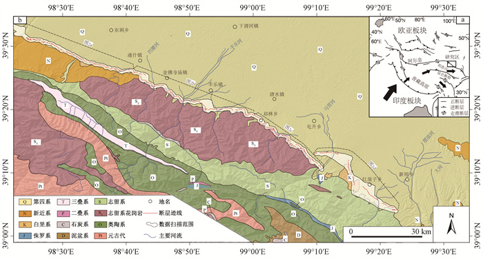
图 1 佛洞庙-红崖子断层及其周缘基础地质图(据Zuza et al., 2016修改;断层迹线数据源自基于高精度地形数据的解译和野外地质调查)
a—印度板块和欧亚板块构造运动示意图;b—研究区地质图
Figure 1. Geological map of the Fodongmiao-Hongyazi Thrust and its surrounding area (modified from Zuza et al., 2016; Fault trace data derived from interpretation based on high-precision (0.5 m) DEM data and field geological surveys)
(a) Schematic diagram of tectonic movements of the Indian Plate and Eurasian Plate; (b) Geological map of the study area


图 3 断错地貌参数分析基本原理图
a—断层几何形态分析的基本参数;b—节点分析中采用的2种重新采样方法;c—断层走向变化计算的基本原理;d—断层粗糙程度计算的基本原理;e—断层变形宽度的基本计算原理
Figure 3. Cartoon showing the basic principle of deformed geomorphic parameters
(a) Basic parameters for geometric analysis of faults; (b) Two resampling methods used in node analysis; (c) Basic principles for calculating fault strike changes; (d) Basic principles for calculating fault roughness; (e) Basic principles for calculating fault deformation width

图 4 断层错断地貌参数分析结果
W—标准化断层距离;x—沿断层方向距离;y—跨断层方向距离;m—中值梯度;n—断层节点数
a—断层迹线分布;b—断层走向变化;c—断层粗糙度分布;d—断层变形带宽度变化Figure 4. Analysis results of faulted landform parameters
(a) Distribution of fault traces; (b) Changes in fault strike; (c) Distribution of fault roughness; (d) Variation in fault deformation zone width
W-Normalized fault distance; x-Distance along the fault direction; y-Distance across the fault direction; m-Median gradient; n-Number of fault nodes
图 5 利用3D fault offsets方法测量垂直位错
a—在高精度数据上对断层位置和测量多边形的选择(背景为山影图);b—基于9个参数对最佳垂直位错的拟合
Figure 5. Measurement of vertical fault offset using 3D fault offsets method
(a) Selection of fault location and measurement polygons on high-precision data (background: hillshade map); (b) Fitting of the optimal vertical fault offset based on nine parameters

图 6 不同宽度的断层阶跃数量统计
Figure 6. Statistical analysis of the amounts of fault steps with different widths

图 7 垂直位错沿断层分布特征
a—断层迹线分布;b—垂直位错沿断层分布(注意位错沿断层走向在不同段落末端两侧的显著线性衰减)
Figure 7. Vertical offset distribution along the FFT thrust
(a) Distribution of fault traces; (b) Distribution of vertical offsets along the thrust (The significant linear attenuation of offsets along the thrust strike on both sides at different segments'ends)

图 8 基岩地质背景与断层分段以及浅表断错地貌参数变化分界的对应性
a—佛洞庙-红崖子断层沿线断错地貌分布(背景为谷歌卫星影像;绿色圆点代表断层分段、断错地貌参数显著变化、垂直位错衰减界线);b—断层东段典型断层陡坎地貌;c—断层中段断层陡坎及基岩分布;d—断层西段断层陡坎及基岩分布
Figure 8. Correspondence between bedrock geology background, fault segmentation, and boundaries of shallow faulted landform parameter changes
(a) Distribution of faulted landforms along the FFT thrust (background image from Google satellite imagery; green dots represent segments of the fault, significant changes in faulted landform parameters, and boundaries of vertical offset attenuation); (b) Typical fault scarp landform in the eastern section of the fault; (c) Fault scarp and bedrock distribution in the middle section of the fault; (d) Fault scarp and bedrock distribution in the western section of the fault
表 1 佛洞庙-红崖子断层垂直位错测量结果(Li et al., 2021)
Table 1. Measurement results of vertical fault offsets for the FFT thrust (Li et al., 2021)
编号 位置 地貌单元 位错/m 误差/m 沿断层距离/km 编号 位置 地貌单元 位错/m 误差/m 沿断层距离/km 52 39°31′6.400″N,98°25′15.231″E Q1 2.1 0.2 1.6 S10 39°20′3.711″N,98°57′49.278″E Q1 2.0 0.1 58.4 51 39°31′6.579″N,98°25′16.466″E Q1 1.2 0.1 1.6 191 39°24′55.72″N,98°42′19.439″E Q1 0.9 0.1 30.3 53 39°31′6.654″N,98°25′17.331″E Q1 1.5 0.1 1.6 T11 39°16′1.451″N,99°4′21.306″E Q1 2.2 0.2 72.7 61 39°31′6.610″N,98°25′24.167″E Q1 2.6 0.2 1.8 T07 39°23′48.478″N,98°45′42.885″E Q1 1.5 0.1 35.6 70 39°30′59.624″N,98°25′47.418″E Q1 1.6 0.1 2.3 358 39°13′27.416″N,99°8′1.821″E Q1 1.9 0.1 80.8 69 39°31′2.293″N,98°26′1.329″E Q1 1.0 0.2 2.7 359 39°13′25.811″N,99°8′3.041″E Q1 1.2 0.1 80.8 401 39°31′3.522″N,98°26′8.152″E Q1 1.3 0.1 2.8 380 39°11′52.574″N,99°9′27.564″E Q1 1.1 0.1 84.3 75 39°31′3.909″N,98°26′10.210″E Q1 1.1 0.1 2.9 381 39°11′51.966″N,99°9′28.033″E Q1 2.0 0.1 84.3 74 39°31′3.966″N,98°26′10.995″E Q1 1.2 0.1 2.9 387 39°11′14.031″N,99°10′14.180″E Q1 1.1 0.1 85.9 73 39°31′4.008″N,98°26′11.854″E Q1 1.1 0.1 2.9 388 39°11′11.761″N,99°10′16.324″E Q1 2.5 0.3 86.1 77 39°31′3.896″N,98°26′12.833″E Q1 1.1 0.1 3.0 389 39°11′8.890″N,99°10′19.493″E Q1 2.0 0.2 86.1 76 39°31′3.743″N,98°26′13.473″E Q1 1.5 0.1 3.0 FD-4 39°13′7.179″N,99°10′31.183″E Q1 1.1 0.1 90.1 78 39°31′2.797″N,98°26′15.857″E Q1 2.9 0.2 3.0 FD-5 39°13′7.081″N,99°10′47.249″E Q1 1.5 0.1 90.5 79 39°31′2.154″N,98°26′16.865″E Q1 2.8 0.2 3.1 FD-6 39°13′9.001″N,99°11′3.138″E Q1 1.7 0.1 91.0 89 39°30′49.016″N,98°26′38.174″E Q1 2.5 0.2 3.8 FD-12 39°13′11.919″N,99°11′34.461″E Q1 1.6 0.2 91.7 95 39°30′30.237″N,98°27′43.896″E Q1 1.3 0.1 5.4 FD-11 39°13′12.715″N,99°11′41.579″E Q1 1.3 0.1 91.9 402 39°30′27.655″N,98°28′4.057″E Q1 1.4 0.1 5.9 FD-29 39°11′1.708″N,99°14′56.572″E Q1 1.4 0.1 100.0 106 39°30′26.815″N,98°28′8.652″E Q1 0.8 0.1 6.0 FD-31 39°11′0.871″N,99°14′56.348″E Q1 1.7 0.1 100.0 107 39°30′26.248″N,98°28′9.930″E Q1 1.3 0.1 6.1 FD-49 39°8′40.218″N,99°15′47.224″E Q1 1.7 0.1 104.3 137 39°29′12.353″N,98°30′21.917″E Q1 0.6 0.0 10.0 FD-50 39°8′36.554″N,99°15′46.859″E Q1 2.3 0.3 104.5 136 39°29′11.633″N,98°30′22.922″E Q1 1.9 0.1 10.2 344 39°14′13.595″N,99°7′15.261″E Q2 2.8 0.1 78.6 152 39°26′25.165″N,98°37′29.506″E Q1 0.9 0.1 21.3 FD-96 39°13′5.994″N,99°9′38.417″E Q2 0.6 0.3 89.0 157 39°26′8.703″N,98°39′50.538″E Q1 2.5 0.1 24.7 FD-1 39°13′4.508″N,99°9′46.262″E Q2 1.0 0.1 89.2 S19 39°30′41.422″N,98°27′6.333″E Q1 1.8 0.1 4.5 FD-0 39°13′4.093″N,99°9′48.952″E Q2 0.6 0.0 89.2 167 39°25′55.230″N,98°41′31.717″E Q1 2.0 0.1 27.4 FD-3 39°13′3.250″N,99°9′53.761″E Q2 1.0 0.1 89.4 168 39°25′54.929″N,98°41′33.039″E Q1 1.4 0.1 27.5 FD-40 39°9′43.974″N,99°15′28.878″E Q2 1.8 0.2 102.4 169 39°25′54.255″N,98°41′34.163″E Q1 1.0 0.1 27.5 FD-41 39°9′46.209″N,99°15′26.700″E Q2 2.0 0.2 102.4 247 39°20′6.106″N,98°54′30.186″E Q1 3.0 0.3 53.3 FD-39 39°9′41.926″N,99°15′30.080″E Q2 1.9 0.2 102.6 248 39°20′5.966″N,98°54′36.697″E Q1 2.4 0.3 53.5 FD-68 39°5′9.240″N,99°20′23.640″E Q2 0.7 0.1 114.5 250 39°20′5.623″N,98°54′41.229″E Q1 2.7 0.1 53.6 FD-69 39°5′6.773″N,99°20′31.440″E Q2 0.9 0.1 114.8 255 39°20′4.501″N,98°57′53.613″E Q1 1.9 0.1 58.5 FD-62 39°6′4.116″N,99°19′3.899″E Q3 1.8 0.1 112.1 271 39°19′12.727″N,98°59′14.263″E Q1 2.5 0.5 61.8 FD-73 39°4′40.353″N,99°21′23.369″E Q3 1.3 0.2 115.9 270 39°19′13.440″N,98°59′15.000″E Q1 2.1 0.3 61.8 FD-74 39°4′40.057″N,99°21′27.551″E Q3 1.2 0.1 116.1 272 39°19′14.662″N,98°59′17.181″E Q1 2.9 0.2 61.9 FD-83 39°4′9.619″N,99°22′0.124″E Q3 0.9 0.1 117.3 293 39°17′6.408″N,99°2′57.950″E Q1 2.5 0.3 69.1 FD-90 39°4′10.223″N,99°22′16.336″E Q3 1.8 0.1 117.9 292 39°17′6.334″N,99°2′59.229″E Q1 1.7 0.1 69.2 FD-92 39°4′9.120″N,99°22′17.760″E Q3 2.8 0.3 118.0 302 39°16′59.760″N,99°3′7.925″E Q1 2.2 0.3 69.6 FD-93 39°4′8.827″N,99°22′18.695″E Q3 1.9 0.1 118.1 313 39°16′0.243″N,99°4′17.027″E Q1 1.6 0.5 72.7 201 39°28′29.930″N,98°31′57.209″E T1 1.9 0.1 12.6 330 39°14′37.583″N,99°5′54.579″E Q1 1.2 0.1 76.7 156 39°26′15.273″N,98°38′50.902″E T1 2.0 0.2 23.5 336 39°14′16.589″N,99°6′20.801″E Q1 2.4 0.2 77.5 202 39°28′29.838″N,98°31′57.840″E T1 1.8 0.1 12.6 337 39°14′16.553″N,99°6′21.925″E Q1 1.6 0.2 77.5 S4 39°21′18.407″N,98°49′2.971″E T1 1.7 0.1 43.8 348 39°13′54.561″N,99°7′29.624″E Q1 1.4 0.1 79.3 158 39°25′52.838″N,98°41′16.634″E T1 1.3 0.1 27.1 S21 39°21′48.422″N,98°47′30.257″E Q1 1.1 0.1 40.6 338 39°14′16.595″N,99°6′23.446″E T1 1.6 0.1 77.7 S23 39°20′3.577″N,98°54′18.734″E Q1 1.3 0.1 53.1 T03 39°23′39.742″N,98°44′27.684″E T1 0.9 0.1 33.7 S24 39°18′26.351″N,99°1′9.873″E Q1 1.9 0.4 65.3 T04 39°23′40.686″N,98°44′29.295″E T1 1.3 0.2 33.7 S25 39°17′58.308″N,99°0′56.699″E Q1 1.5 0.2 66.1 S15 39°32′54.410″N,98°23′45.904″E T3 1.7 0.1 -2.9 S0 39°25′44.639″N,98°41′59.328″E Q1 1.6 0.1 28.2 S16 39°32′51.425″N,98°23′51.211″E T3 1.7 0.1 -2.7 S1 39°24′41.663″N,98°42′25.855″E Q1 2.2 0.1 30.8 S17 39°32′48.633″N,98°23′54.546″E T3 1.8 0.1 -2.6 S3 39°22′53.807″N,98°46′20.936″E Q1 1.4 0.1 37.7 S18 39°32′46.197″N,98°23′57.462″E T3 1.5 0.1 -2.5 S5 39°21′9.426″N,98°50′40.849″E Q1 2.1 0.2 46.4 S12 39°32′54.357″N,98°23′31.462″E T4 1.9 0.1 -3.2 S6 39°21′18.984″N,98°51′18.382″E Q1 1.6 0.1 47.4 S13 39°32′54.385″N,98°23′39.885″E T4 1.9 0.1 -3.0 S7 39°20′8.964″N,98°55′18.838″E Q1 1.7 0.1 54.7 S14 39°32′54.630″N,98°23′35.608″E T4 1.5 0.1 -3.1 S8 39°20′2.760″N,98°57′44.640″E Q1 1.6 0.1 58.3 FD-15 39°13′12.352″N,99°12′19.827″E T4 1.3 0.1 92.8 S9 39°20′4.348″N,98°57′52.596″E Q1 1.5 0.1 58.5 FD-18 39°13′8.358″N,99°12′50.389″E T4 1.6 0.2 93.5 注:T1—第一级河流阶地;Q1—第一级洪积扇;T2—第二级河流阶地;Q2—第二级洪积扇;Q3—第三级洪积扇  下载: 导出CSV
-
BARKA A A, KADINSKY-CADE K, 1988. Strike-slip fault geometry in Turkey and its influence on earthquake activity[J]. Tectonics, 7(3): 663-684. doi: 10.1029/TC007i003p00663 BASTESEN E, BRAATHEN A, 2010. Extensional faults in fine grained carbonates-analysis of fault core lithology and thickness-displacement relationships[J]. Journal of Structural Geology, 32(11): 1609-1628. doi: 10.1016/j.jsg.2010.09.008 BEDFORD J D, FAULKNER D R, LAPUSTA N, 2022. Fault rock heterogeneity can produce fault weakness and reduce fault stability[J]. Nature Communications, 13(1): 326. doi: 10.1038/s41467-022-27998-2 CARPENTER B M, MARONE C, SAFFER D M, 2011. Weakness of the San Andreas Fault revealed by samples from the active fault zone[J]. Nature Geoscience, 4(4): 251-254. doi: 10.1038/ngeo1089 CHEN B L, LIU J S, ZHANG Y S, et al., 2010. Estimation of major earthquake cycle and future tendency in Hexi corridor and its adjacent area, NW China[J]. Journal of Geomechanics, 16(2): 159-175. (in Chinese with English abstract) doi: 10.3969/j.issn.1006-6616.2010.02.006 CHEN T, LIU-ZENG J, SHAO Y X, et al., 2018. Geomorphic offsets along the creeping Laohu Shan section of the Haiyuan fault, northern Tibetan Plateau[J]. Geosphere, 14(3): 1165-1186. doi: 10.1130/GES01561.1 CHOI J H, KLINGER Y, FERRY M, et al., 2018. Geologic inheritance and earthquake rupture processes: The 1905 M ≥ 8 Tsetserleg-Bulnay strike-slip earthquake sequence, Mongolia[J]. Journal of Geophysical Research: Solid Earth, 123(2): 1925-1953. doi: 10.1002/2017JB013962 COLLETTINI C, NIEMEIJER A, VITI C, et al., 2009. Fault zone fabric and fault weakness[J]. Nature, 462(7275): 907-910. doi: 10.1038/nature08585 DUAN B C, OGLESBY D D, 2006. Heterogeneous fault stresses from previous earthquakes and the effect on dynamics of parallel strike-slip faults[J]. Journal of Geophysical Research: Solid Earth, 111(B5): B05309. GU G X, 1983. Catalogue of earthquakes in China (1831 BC-1969 AD)[M]. Beijing: Science Press. (in Chinese) HADDON E K, AMOS C B, ZIELKE O, et al., 2016. Surface slip during large Owens Valley earthquakes[J]. Geochemistry, Geophysics, Geosystems, 17(6): 2239-2269. doi: 10.1002/2015GC006033 HETZEL R, HAMPEL A, GEBBEKEN P, et al., 2019. A constant slip rate for the western Qilian Shan frontal thrust during the last 200 ka consistent with GPS-derived and geological shortening rates[J]. Earth and Planetary Science Letters, 509: 100-113. doi: 10.1016/j.epsl.2018.12.032 HU X F, PAN B T, KIRBY E, et al., 2015. Rates and kinematics of active shortening along the eastern Qilian Shan, China, inferred from deformed fluvial terraces[J]. Tectonics, 34(12): 2478-2493. doi: 10.1002/2015TC003978 HUANG X N, YANG H B, YANG X P, et al., 2021. Holocene paleoeseismology of the Fodongmiao-Hongyazi Fault along the Northern Tibetan margin (Western China) and implication to intraplate earthquake rupturing pattern[J]. Tectonophysics, 808: 228812. doi: 10.1016/j.tecto.2021.228812 Institute of Geology, State Seismological Bureau, Lanzhou Institute of Seismology, State Seismological Bureau. 1993. The Qilian Mountain-Hexi Corridor Active Fault System [M]. Seismological Press, Beijing: 19—228 (in Chinese) KANG W J, XU X W, OSKIN M E, et al., 2020. Characteristic slip distribution and earthquake recurrence along the eastern Altyn Tagh fault revealed by high-resolution topographic data[J]. Geosphere, 16(1): 392-406. doi: 10.1130/GES02116.1 KLINGER Y, ETCHEBES M, TAPPONNIER P, et al., 2011. Characteristic slip for five great earthquakes along the Fuyun fault in China[J]. Nature Geoscience, 4(6): 389-392. doi: 10.1038/ngeo1158 LI H Q, YUAN D Y, SU Q, et al., 2023. Geomorphic features of the Menyuan basin in the Qilian Mountains and its tectonic significance[J]. Journal of Geomechanics, 29(6): 824-841. (in Chinese with English Abstract) LI Z F, XU X W, TAPPONNIER P, et al., 2021. Post-20 ka earthquake scarps along NE-Tibet's Qilian Shan frontal Thrust: Multi-millennial return, ~characteristic co-seismic slip, and geological rupture control[J]. Journal of Geophysical Research: Solid Earth, 126(12): e2021JB021889. doi: 10.1029/2021JB021889 LIU X W, YUAN D Y, HE W G, 2014. Preliminary study of palaeo-earthquakes on the Fodongmiao-Hongyazi fault in the north margin of Qilian mountain [J]. Technology for Earthquake Disaster Prevention, 9(3): 411-419. (in Chinese with English Abstract) LIU X W, YUAN D Y, SU Q, 2019. Late Pleistocene slip rate on a blind thrust in the western Qilian Shan, NW China[J]. Geomorphology, 345: 106841. doi: 10.1016/j.geomorph.2019.106841 LIU X W, YUAN D Y, SHAO Y X, et al., 2022. Re-evaluation of surface ruptures produced by the 1609 M 7.3 Hongyazi earthquake in the northern Qilian Shan, China[J]. Arabian Journal of Geosciences, 15(6): 542. doi: 10.1007/s12517-021-08633-8 LIU-ZENG J, YAO W Q, LIU X L, et al., 2022. High-resolution structure-from-motion models covering 160 km-long surface ruptures of the 2021 MW 7.4 Madoiearthquake in northern Qinghai-Tibetan Plateau[J]. Earthquake Research Advances, 2(2): 100140. doi: 10.1016/j.eqrea.2022.100140 MANIGHETTI I, KING G C P, GAUDEMER Y, et al., 2001. Slip accumulation and lateral propagation of active normal faults in Afar[J]. Journal of Geophysical Research: Solid Earth, 106(B7): 13667-13696. doi: 10.1029/2000JB900471 MANIGHETTI I, MERCIER A, DE BARROS L, 2021. Fault trace corrugation and segmentation as a measure of fault structural maturity[J]. Geophysical Research Letters, 48(20): e2021GL095372. doi: 10.1029/2021GL095372 MATTÉO L, MANIGHETTI I, TARABALKA Y, et al., 2021. Automatic fault mapping in remote optical images and topographic data with deep learning[J]. Journal of Geophysical Research: Solid Earth, 126(4): e2020JB021269. doi: 10.1029/2020JB021269 PERRIN C, MANIGHETTI I, AMPUERO J P, et al., 2016. Location of largest earthquake slip and fast rupture controlled by along-strike change in fault structural maturity due to fault growth[J]. Journal of Geophysical Research: Solid Earth, 121(5): 3666-3685. doi: 10.1002/2015JB012671 REN J J, XU X W, ZHANG G W, et al., 2022. Coseismic surface ruptures, slip distribution, and 3D seismogenic fault for the 2021 Mw 7.3 Maduo earthquake, central Tibetan Plateau, and its tectonic implications[J]. Tectonophysics, 827: 229275. doi: 10.1016/j.tecto.2022.229275 REN Z K, ZHANG Z Q, CHEN T, et al., 2016. Clustering of offsets on the Haiyuan fault and their relationship to paleoearthquakes[J]. GSA Bulletin, 128(1-2): 3-18. SCHOLZ C H, ENGELDER J T, 1976. The role of asperity indentation and ploughing in rock friction—I: Asperity creep and stick-slip[J]. International Journal of Rock Mechanics and Mining Sciences & Geomechanics Abstracts, 13(5): 149-154. SIBSON R H, 1977. Fault rocks and fault mechanisms[J]. Journal of the Geological Society, 133(3): 191-213. doi: 10.1144/gsjgs.133.3.0191 STEWART N, GAUDEMER Y, MANIGHETTI I, et al., 2018. "3D_Fault_Offsets, " a Matlab code to automatically measure lateral and vertical fault offsets in topographic data: application to San Andreas, Owens Valley, and Hope faults[J]. Journal of Geophysical Research: Solid Earth, 123(1): 815-835. doi: 10.1002/2017JB014863 TAPPONNIER P, MEYER B, AVOUAC J P, et al., 1990. Active thrusting and folding in the Qilian Shan, and decoupling between upper crust and mantle in northeastern Tibet[J]. Earth and Planetary Science Letters, 97(3-4): 382-383, 387-403. doi: 10.1016/0012-821X(90)90053-Z WESNOUSKY S G, 2008. Displacement and geometrical characteristics of earthquake surface ruptures: Issues and implications for seismic-hazard analysis and the process of earthquake rupture[J]. Bulletin of the Seismological Society of America, 98(4): 1609-1632. doi: 10.1785/0120070111 XIONG J G, LI Y L, ZHONG Y Z, et al., 2017. Latest Pleistocene to Holocene thrusting recorded by a flight of strath terraces in the eastern Qilian Shan, NE Tibetan Plateau[J]. Tectonics, 36(12): 2973-2986. doi: 10.1002/2017TC004648 XU X W, WEN X Z, YU G H, et al., 2009. Coseismic reverse- and oblique-slip surface faulting generated by the 2008 Mw 7.9 Wenchuan earthquake, China[J]. Geology, 37(6): 515-518. doi: 10.1130/G25462A.1 XU X W, WU X Y, YU G H, et al., 2017. Seismo-geological signatures for identifying M≥7.0 earthquake risk areas and their premilimary application in China's mainland[J]. Seismology and Geology, 39(2): 219-275. (in Chinese with English abstract) doi: 10.3969/j.issn.0253-4967.2017.02.001 XU X W, YEATS R S, YU G H, 2010. Five short historical earthquake surface ruptures near the Silk Road, Gansu Province, China[J]. Bulletin of the Seismological Society of America, 100(2): 541-561. doi: 10.1785/0120080282 YANG H B, YANG X P, HUANG X N, 2017. A preliminary study about slip rate of middle segment of the northern Qilian thrust fault zone since late quaternary[J]. Seismology and Geology, 39(1): 20-42. (in Chinese with English abstract) YANG H B, YANG X P, HUANG X N, et al., 2018. New constraints on slip rates of the Fodongmiao-Hongyazi fault in the Northern Qilian Shan, NE Tibet, from the 10Be exposure dating of offset terraces[J]. Journal of Asian Earth Sciences, 151: 131-147. doi: 10.1016/j.jseaes.2017.10.034 YUAN D Y, GE W P, CHEN Z W, et al., 2013. The growth of northeastern Tibet and its relevance to large-scale continental geodynamics: A review of recent studies[J]. Tectonics, 32(5): 1358-1370. doi: 10.1002/tect.20081 ZHANG D, LI J C, WU Z H, et al., 2021. Using terrestrial LiDAR to accurately measure the micro-geomorphologic geometry of active fault: A case study of fault scarp on the Maoyaba fault zone[J]. Journal of Geomechanics, 27(1): 63-72. (in Chinese with English abstract) ZHANG P Z, SHEN Z K, WANG M, et al., 2004. Continuous deformation of the Tibetan Plateau from global positioning system data[J]. Geology, 32(9): 809-812. doi: 10.1130/G20554.1 ZHANG P Z, DENG Q D, ZHANG Z Q, et al., 2013. Active faults, earthquake disasters and their dynamic processes in Chinese Mainland[J]. Chinese Science: Earth Sciences, 43(10): 1607-1620. (in Chinese) ZHENG D W, CLARK M K, ZHANG P Z, et al., 2010. Erosion, fault initiation and topographic growth of the North Qilian Shan (northern Tibetan Plateau)[J]. Geosphere, 6(6): 937-941. doi: 10.1130/GES00523.1 ZHENG W J, ZHANG H P, ZHANG P Z, et al., 2013. Late Quaternary slip rates of the thrust faults in western Hexi Corridor (Northern Qilian Shan, China) and their implications for northeastward growth of the Tibetan Plateau[J]. Geosphere, 9(2): 342-354. doi: 10.1130/GES00775.1 ZHENG W J, ZHANG Z Q, HAO M, et al., 2022. Physical basis for prediction of continental strong earthquakes: Development and prospect of active tectonic block theory[J]. Chinese Science Bulletin, 67(13): 1352-1361. (in Chinese with English abstract) ZHANG X Z, TIE Y B, LI G H, et al., 2022. Characteristics and risk assessment of debris flows in the Wandong catchment after the MS 6.8 Luding earthquake. Journal of Geomechanics, 28 (6): 1035-1045. (in Chinese with English abstract) ZIELKE O, 2010. Slip in the 1857 and earlier large earthquakes along the Carrizo Plain, San Andreas Fault (Science (1119))[J]. Science, 329(5990): 390. ZUZA A V, CHENG X G, YIN A, 2016. Testing models of Tibetan Plateau formation with Cenozoic shortening estimates across the Qilian Shan-Nan Shan thrust belt[J]. Geosphere, 12(2): 501-532. 陈柏林, 刘建生, 张永双, 等, 2010. 河西走廊及邻区大震重复周期估算与未来地震趋势[J]. 地质力学学报, 16(2): 159-175. https://journal.geomech.ac.cn/article/id/595a9e5d-d0a0-4928-ac94-43967c45ca04?viewType=HTML 顾功叙, 1983. 中国地震目录(公元前1831-公元1969年)[M]. 北京: 科学出版社. 国家地震局地质研究所, 国家地震局兰州地震研究所, 1993. 祁连山-河西走廊活动断层系[M]. 北京: 地震出版社. 刘兴旺, 袁道阳, 何文贵, 2014. 祁连山北缘佛洞庙-红崖子断层古地震特征初步研究[J]. 震灾防御技术, 9(3): 411-419. https://www.cnki.com.cn/Article/CJFDTOTAL-ZZFY201403007.htm 李红强, 袁道阳, 苏琦, 等, 2023. 祁连山内部门源盆地地貌特征及构造意义[J]. 地质力学学报, 29(6): 824-841. doi: 10.12090/j.issn.1006-6616.2023123?viewType=HTML 徐锡伟, 吴熙彦, 于贵华, 等, 2017. 中国大陆高震级地震危险区判定的地震地质学标志及其应用[J]. 地震地质, 39(2): 219-275. https://www.cnki.com.cn/Article/CJFDTOTAL-DZDZ201702001.htm 杨海波, 杨晓平, 黄雄南, 2017. 祁连山北缘断层带中段晚第四纪活动速率初步研究[J]. 地震地质, 39(1): 20-42. 张迪, 李家存, 吴中海, 等, 2021. 利用地面LiDAR精细化测量活断层微地貌形态: 以毛垭坝断层禾尼处断层崖为例[J]. 地质力学学报, 27(1): 63-72. doi: 10.12090/j.issn.1006-6616.2021.27.01.007?viewType=HTML 张培震, 邓起东, 张竹琪, 等, 2013. 中国大陆的活动断层、地震灾害及其动力过程[J]. 中国科学: 地球科学, 43(10): 1607-1620. https://www.cnki.com.cn/Article/CJFDTOTAL-JDXK201310005.htm 张宪政, 铁永波, 李光辉, 等, 2022. 四川泸定MS6.8级地震区湾东河流域泥石流活动性预测. 地质力学学报, 28 (6): 1035-1045. https://www.cnki.com.cn/Article/CJFDTOTAL-SLXB202305009.htm 郑文俊, 张竹琪, 郝明, 等, 2022. 强震孕育发生的大陆活动地块理论未来发展与强震预测探索[J]. 科学通报, 67(13): 1352-1361. https://www.cnki.com.cn/Article/CJFDTOTAL-KXTB202213002.htm -

 下载:
下载:


 点击查看大图
计量
- 文章访问数: 68
- HTML全文浏览量: 15
- PDF下载量: 8
- 被引次数: 0
