

EXPLORATION AND PRACTICE OF 1: 50000 GEOLOGICAL MAPPING TECHNIQUES FOR ALPINE-GORGE AREA: A CASE STUDY IN BEISHAN AREA OF WUSHI, XINJIANG
-
摘要: 新疆乌什北山填图试点项目充分发挥遥感技术的先导作用,探索1:50000高山峡谷区填图方法。不同分辨率遥感数据在岩性、构造解译等方面的差异表明多源遥感数据综合解译能有效提高解译程度。研究认为同一遥感数据最佳波段组合图像、Landsat-8和Worldview-2数据协同图像增强了对岩性和构造识别的能力。高光谱遥感矿物填图和岩性分类、基于ASTER热红外遥感数据的岩石化学成分填图等是高山峡谷区填图有效技术方法。利用ETM和ASTER数据开展矿化蚀变信息提取,结果表明ASTER较ETM数据在铁染异常、羟基异常等提取方面具有更大的优势。分析认为多元信息综合预测是区域找矿的重要途径。根据乌什北山地质地貌特征,选择其中有效技术方法或技术方法组合开展1:50000地质填图,结果显示在减少剖面测制和路线地质调查数量的同时,达到了填图精度,并取得了若干重要研究成果,为区域构造演化和成矿规律分析总结提供了资料支撑。Abstract: The 1:50000 geological mapping project makes sufficient use of remote sensing technologies to explore new methods of geological mapping in alpine-gorge area of Wushi, Xinjiang. Different spatial resolution remote sensing data can reveal different characteristics of lithology and structures. Integrated interpretations of multi-source remote sensing data can enhance the ability of interpretation effectively. Higher accuracy interpretations of lithologic classification can be obtained by combination of different bands of the same remote sensing image according to the optimum index factor (OIF) and synergestic images of Landsat-8 and worldview-2. Hyperspectral mineral mapping and lithology identification, petrochemistry components mapping using ASTER thermal infrared remote sensing data are useful technologies of geological mapping in alpine-gorge area. Both of the ETM and ASTER data were used to extract alteration information. The result shows that the ASTER data is more useful than ETM data in extracting alteration anomalies, such as ferric contamination anomaly and hydroxyl anomaly. Therefore, it is an important way of multivariate information comprehensive analysis to prospect. Based on the geological and geomorphological features, effective techniques have been selected to complete 1:50000 geological mapping of the North Mountain, Wushen area, and important research results have been obtained. The sufficient use of remote sensing data can reduce the amount of geologic section and geological survey routes, and achieve the mapping precision.
-

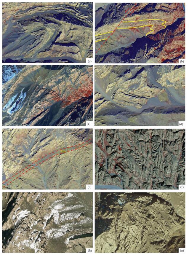
图 2 同一地区不同空间分辨率遥感数据岩性解译效果对比图
a—Spot5遥感影像图; b—Spot6遥感影像图; c—Geoeye-1遥感影像图; d—Quickbird遥感影像图; e—Worldview-2遥感影像图; f—Worldview-3遥感影像局部放大图; g—高分一号遥感影像图; h—高分二号遥感影像图
Figure 2. Comparison of lithologic interpretation of remote sensing data with different spatial resolution in the same area

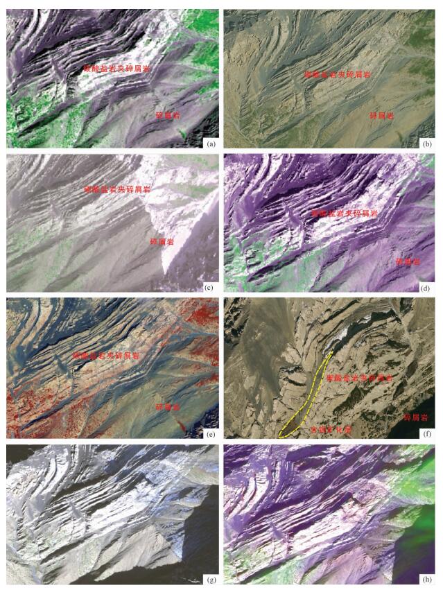
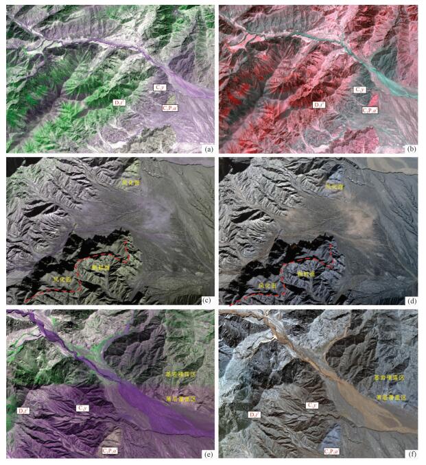
图 3 不同空间分辨率遥感数据构造解译效果对比图
a—斜歪倾伏褶皱影像; b—不对称褶皱影像; c—2褶皱构造影像(局部剥蚀露); d—断层构造影像; e—断层破碎带影像; f—两期节理构造影像; h—层理、劈理构造影像; g—两期劈理构造影像(a—f为Worldview-2数据; h—g为Worldview-3数据)
Figure 3. Comparison of structure interpretation of remote sensing data with different spatial resolution

图 5 Landsat-8和Worldview-2协同影像图
Figure 5. The synergestic image of Landsat-8 and Worldview-2

图 6 同一遥感数据不同波段组合图像解译效果对比
Figure 6. Comparison charts for different bands combined image of a remote sensing data

图 7 ETM和ASTER遥感数据矿化蚀变信息对比图
a—ETM比值法铁染异常信息; b—ETM主成分分析法铁染异常信息; c—ETM比值法羟基异常信息; d—ETM主成分分析法羟基异常信息; e—ASTER主成分分析法铁染异常信息; f—第一组羟基异常信息; g—第一组羟基异常信息; h—CO32-离子团异常信息
Figure 7. Images of alteration minerals produced from ETM and ASTER remote sensing data
表 1 Spot5影像各波段数据统计特征值及各波段间相关系数矩阵
Table 1. Statistic eigenvalues and correlation coefficient matrix for bands of SPOT5
波段 最小值 最大值 均值 标准差 相关系数 Band 1 Band 2 Band 3 Band 4 Band 1 0 255 77.485 33.134 Band 1 1.000000 0.897210 0.886567 0.848133 Band 2 0 255 56.163 31.990 Band 2 0.897210 1.000000 0.994379 0.707432 Band 3 0 255 56.588 30.646 Band 3 0.886567 0.994379 1.000000 0.668707 Band 4 15 201 87.089 24.271 Band 4 0.848133 0.707432 0.668707 1.000000  下载: 导出CSV
表 2 Quickbird影像各波段数据统计特征值及各波段间相关系数矩阵
Table 2. Statistic eigenvalues and correlation coefficient matrix for bands of Quickbird
波段 最小值 最大值 均值 标准差 相关系数 Band 1 Band 2 Band 3 Band 4 Band 1 0 1342 507.711 166.118 Band 1 1.000000 0.799445 0.817561 0.775338 Band 2 0 1178 384.326 129.077 Band 2 0.799445 1.000000 0.986813 0.954843 Band 3 0 1425 482.756 142.270 Band 3 0.817561 0.986813 1.000000 0.984581 Band 4 0 802 294.572 76.028 Band 4 0.775338 0.954843 0.984580 1.000000
下载: 导出CSV
表 3 Geoeye-1影像各波段数据统计特征值及各波段间相关系数矩阵
Table 3. Statistic eigenvalues and correlation coefficient matrix for bands of Geoeye-1
波段 最小值 最大值 均值 标准差 相关系数 Band 1 Band 2 Band 3 Band 4 Band 1 0 3061 246.776 490.529 Band 1 1.000000 0.990143 0.979206 0.953965 Band 2 0 1682 117.880 212.023 Band 2 0.990143 1.000000 0.993400 0.973462 Band 3 0 2655 262.247 296.175 Band 3 0.979206 0.993400 1.000000 0.991808 Band 4 0 2086 233.266 173.932 Band 4 0.953965 0.973462 0.991808 1.000000
下载: 导出CSV
表 4 ETM1, 3, 4, 5波段主成分变换特征向量矩阵
Table 4. Eigenvector statistics for ETM band 1, 3, 4 and 5
主成分 TM1 TM3 TM4 TM5 PC1 0.45460 0.55101 0.47559 0.51336 PC2 -0.55332 -0.39852 0.24776 0.68821 PC3 -0.10604 0.38590 -0.80948 0.42962 PC4 -0.68988 0.62342 0.23910 -0.27974
下载: 导出CSV
表 5 ETM 1, 4, 5, 7波段主成分变换特征向量矩阵
Table 5. Eigenvector statistics for ETM band 1, 4, 5 and 7
主成分 TM1 TM4 TM5 TM7 PC1 0.46652 0.50298 0.55470 0.47083 PC2 0.77310 0.16771 -0.47247 -0.38855 PC3 -0.40502 0.80432 -0.02006 -0.43431 PC4 0.14367 -0.26823 0.68460 -0.66237
下载: 导出CSV
表 6 ASTER 1, 2, 3, 4波段主成分变换特征向量矩阵
Table 6. Eigenvector statistics for ASTER band 1, 2, 3 and 4
主成分 ASTER1 ASTER2 ASTER3 ASTER4 PC1 -0.32791 -0.36411 -0.46219 -0.73910 PC2 0.52264 0.53843 0.20825 -0.62736 PC3 0.24623 0.37636 -0.85951 0.24283 PC4 -0.74746 0.66020 0.06524 -0.03442
下载: 导出CSV
表 7 ASTER 1, 3, 4, (5+6)/2主成分变换特征向量矩阵
Table 7. Eigenvector statistics for ASTER band 1、3、4 and (5+6)/2
主成分 ASTER1 ASTER3 ASTER4 ASTER(5+6)/2 PC1 0.29182 0.41810 0.68145 0.52503 PC2 0.63120 0.57799 -0.30069 -0.42084 PC3 -0.51442 0.35968 0.47487 -0.61685 PC4 -0.50180 0.60146 -0.46873 0.40833
下载: 导出CSV
表 8 ASTER 1, 3, 4, 8主成分变换特征向量矩阵
Table 8. Eigenvector statistics for ASTER band 1、3、4 and 8
主成分 ASTER1 ASTER3 ASTER4 ASTER8 PC1 0.29166 0.41401 0.68170 0.52803 PC2 0.49962 0.64353 -0.17682 -0.55225 PC3 0.70933 -0.30017 -0.46186 0.43982 PC4 -0.40270 0.56953 -0.53918 0.47197
下载: 导出CSV
表 9 ASTER1、ASTER3、ASTER4、ASTER5主成分变换特征向量矩阵
Table 9. Eigenvector statistics for ASTER band 1、3、4 and 5
主成分 ASTER1 ASTER3 ASTER4 ASTER5 PC1 0.28050 0.39882 0.65579 0.57637 PC2 0.57972 0.64566 -0.27923 -0.41119 PC3 -0.70521 0.53074 0.29824 -0.36338 PC4 0.29652 -0.37733 0.63484 -0.60554
下载: 导出CSV
-
[1] 李建星, Chen She fa, 毛晓长, 等.中(西)澳地质填图对比及对中国地质填图的启示[J].地质通报, 2015, 34(12):2143~2149. doi: 10.3969/j.issn.1671-2552.2015.12.001LI Jian-xing, CHEN She-fa, MAO Xiao-chang, et al. A comparison of geological mapping between Geological Survey of Western Australia and China Geological Survey and its enlightenment for China's geological mapping[J]. Geological Bulletin of China, 2015, 34(12):2143~2149. doi: 10.3969/j.issn.1671-2552.2015.12.001 [2] 刘树臣, 谭永杰, 白冶, 等.当代世界地质调查工作发展趋势[J].地质通报, 2003, 22(8):613~618. http://www.cnki.com.cn/Article/CJFDTOTAL-ZQYD200308009.htmLIU Shu-chen, TAN Yong-jie, BAI Ye, et al. Current trends in geological survey of the world[J]. Geological Bulletin of China, 2003, 22(8):613~618. http://www.cnki.com.cn/Article/CJFDTOTAL-ZQYD200308009.htm [3] 施俊法, 唐金荣, 周平, 等.世界地质调查工作发展趋势及其对中国的启示[J].地质通报, 2014, 33(10):1465~1472. doi: 10.3969/j.issn.1671-2552.2014.10.001SHI Jun-fa, TANG Jin-rong, ZHOU Ping, et al. Development trend of international geological survey and its implications to China[J]. Geological Bulletin of China, 2014, 33(10):1465~1472. doi: 10.3969/j.issn.1671-2552.2014.10.001 [4] 胡道功, PATRICK J Barosh, 吴珍汉, 等.中美合作东昆仑造山带地质填图的启示:填图理念与填图方法[J].地质通报, 2009, 28(10):1411~1418. doi: 10.3969/j.issn.1671-2552.2009.10.007HU Dao-gong, PATRICK J Barosh, WU Zhen-han, et al. Inspirations from the Sino-U.S. cooperative geological mapping in the East Kunlun orogenic belt:ideas and methods[J]. Geological Bulletin of China, 2009, 28(10):1411~1418. doi: 10.3969/j.issn.1671-2552.2009.10.007 [5] 胡建民.探索与创新特殊地质地貌区现代地质填图技术方法[J].中国地质调查成果快讯, 2016, 1(22):1~7. http://www.cnki.com.cn/Article/CJFDTOTAL-DZLX201702001.htmHu Jian-min. Exploration and innovation of modern geological mapping techniques in special geological and landformareas. New Lettres of China Geological Survey, 2016, 1(22):1~7. http://www.cnki.com.cn/Article/CJFDTOTAL-DZLX201702001.htm [6] 辜平阳, 陈瑞明.西南天山高山峡谷区区域地质调查新方法和新进展[J].中国地质调查成果快讯, 2016, 1(22):1~7.GU Ping-yang, CHEN Ring-ming. New methods for regional geological survey and recent progress in Southwest Tianshan tough and dangerous area, Xinjiang[J]. New Lettres of China Geological Survey, 2016, 1(22):28~30. [7] 田淑芳, 詹骞.遥感地质学[M].北京:地质出版社, 2013:47~48.TIAN Shu-fang, ZHAN Qian. Remote Sensing Geology[M]. Beijing:Geological Publishing House, 2013:47~48. [8] 李永军, 梁积伟, 杨高学, 等.区域地质调查导论[M].北京:地质出版社, 2013:152~173.LI Yong-jun, LIANG Ji-wei, YANG Gao-xue, et al. Introduction to regional geological survey[M]. Beijing:Geological Publishing House, 2013:152~173. [9] 张策, 彭莉红, 汪冰, 等. WorldView-2影像在新疆迪木那里克地区火山沉积变质型铁矿勘查中的应用[J].矿产勘查, 2015, 6(5):523~528. http://www.cnki.com.cn/Article/CJFDTOTAL-YSJS201505005.htmZHANG Ce, PENG Li-hong, WANG Bing. et al. Application of worldview-2 remote sensing image in the exploration of the volcano-sedimentary metamorphic type iron deposits in the Dimunalike area, Xinjiang[J]. Mineral Exploation, 2015, 6(5):523~528. http://www.cnki.com.cn/Article/CJFDTOTAL-YSJS201505005.htm [10] 杨敏, 李健强, 高婷, 等. WorldView-2数据在地质调查中的应用[J].现代矿业, 2012, 6:35~37. doi: 10.3969/j.issn.1674-6082.2012.01.009YANG Ming, LI Jian-qiang, GAO Ting, et al. Application of WorldView-2 data in Geological Survey[J]. Morden Mining, 6:35~37. doi: 10.3969/j.issn.1674-6082.2012.01.009 [11] 马熹肇. 资源一号"02C"卫星数据在轨测试分析[D]. 长春: 吉林大学, 2012.MA Xi-zhao.Data analysis on in-orbit testing of Ziyuan 1-02C satellite[D].Changchun:Jilin university, 2012. [12] 文雄飞, 陈蓓青, 申邵洪, 等.资源一号02C卫星P/MS传感器数据质量评价及其在水利行业中的应用潜力分析[J].长江科学院院报, 2012, 29(10):118~121. doi: 10.3969/j.issn.1001-5485.2012.10.023WEN Xiong-fei, CHEN Bei-qin, SHEN Zhao-hong, et al.Image quality evaluation for ZY-102C satellite P/MS sensors and the potential of its application in water conservancy[J].Journal of Yangtze River Scientific Research Institute, 2012, 29(10):118~121. doi: 10.3969/j.issn.1001-5485.2012.10.023 [13] 邱学雷.高分一号卫星工程首批影像图发布将为国土、环境、农业等领域提供精准服务[J].国防科技工业, 2013, (6):14~16. http://www.cnki.com.cn/Article/CJFDTOTAL-ZGBG201306007.htmQIU Xue-lei.Gaofen-1 satellite first released image map which will peovide accurate service to land resources, environment and agriculture[J]. Defence Science and Technology Industry, 2013, (6):14~16. http://www.cnki.com.cn/Article/CJFDTOTAL-ZGBG201306007.htm [14] 梁树能, 魏红艳, 甘甫平, 等. "高分二号"卫星数据在遥感地质调查中的初步应用评价[J].航天返回与遥感, 2015, 36(4):63~72. http://www.cnki.com.cn/Article/CJFDTOTAL-HFYG201504015.htmLIANG Shu-neng, WEI Hong-yan, GAN Fu-ping, et al. Preliminary application evaluation of GF-2 satellite data in remote sensing geological survey[J]. Space Craft Recovery & Remote Sensing, 2015, 36(4):63~72. http://www.cnki.com.cn/Article/CJFDTOTAL-HFYG201504015.htm [15] 陈玲, 梁树能, 周艳, 等.国产高分卫星数据在高海拔地区地质调查中的应用潜力分析[J], 国土资源遥感, 2015, 27(3):140~145. doi: 10.6046/gtzyyg.2015.01.22CHEN Lin, LIANG Shu-neng, ZHOU Yan, et al.Potential of applying domestic high-resolution remote sensing data to geological survey in high altitudes[J].Remote Sensing for Land and Resources, 2015, 27(1):140~145. doi: 10.6046/gtzyyg.2015.01.22 [16] 邓琳, 邓明镜, 张力树.高分辨率遥感影像阴影检测与补偿方法优化[J].遥感技术与应用, 2015, 30(2):277~284. http://www.cnki.com.cn/Article/CJFDTOTAL-YGJS201502011.htmDENG Lin, DENG Ming-jin, ZHANG Li-shu. Optimization of shadow detection and compensation method for High-resolution remote sensing images[J]. Remote Sensing Technology and application, 2015, 30(2):277~284. http://www.cnki.com.cn/Article/CJFDTOTAL-YGJS201502011.htm [17] Etemadnia H, Alsharif MR.Automatic image shadow identi-fication using LPF in Homomo rphic Processing System Ⅶ digital image computing[J]. Techniques and Applications, Sydney, 2003:429~438. [18] 虢建宏, 田庆久, 吴昀昭.遥感影像多波段检测与去除理论模型研究[J].遥感学报, 2006, 10(2):151~159. http://www.cnki.com.cn/Article/CJFDTOTAL-YGXB200602001.htmUO Jiang-hong, TIAN Qing-jiu, WU Yun-zhao. Study on Multi-spectral detecting shadow areas and a theoretical model of removing shadows from remote sensing images[J]. Journal of Remote Sensing, 2006, 10(2):151~159. http://www.cnki.com.cn/Article/CJFDTOTAL-YGXB200602001.htm [19] 高贤君, 万幼川, 郑顺义, 等.航空遥感影像阴影的自动检测与补偿[J].武汉大学学报(信息科学版), 2012, 37(11):1299~1302. http://www.cnki.com.cn/Article/CJFDTOTAL-WHCH201211010.htmGAO Xian-jun, WAN You-chuan, ZHENG Shun-yi, et al. Automatic shadow detection and compensation of aerial remote sensing images[J]. Geomatics and Information Science of WuhanUniversity, 2012, 37(11):1299~1302. http://www.cnki.com.cn/Article/CJFDTOTAL-WHCH201211010.htm [20] 杨俊, 赵忠明, 杨健.一种高分辨率遥感影像阴影去除力法[J].武汉大学学报(信息科学版), 2008, 33(1):20~33. http://www.cnki.com.cn/Article/CJFDTOTAL-WHCH200801004.htmYANG Jun, ZHAO Zhongming, YANG Jian. A shadow removal method for high resolution remote sensing image[J]. Geomatics and Information Science of Wuhan University, 2008, 33(1):20~33. http://www.cnki.com.cn/Article/CJFDTOTAL-WHCH200801004.htm [21] 张斌, 张志, 帅爽, 等.利用Landsat-8和worldview-2数据进行协同岩性分类[J].地质科技情报, 2015, 34(3):208~213. http://www.cnki.com.cn/Article/CJFDTOTAL-DZKQ201503030.htmZHANG Bin, ZHANG Zhi, SHUAI Shang, et al. Lithological mapping by using the synergestic Land-8 and Worldview-2 images[J]. Geological Science and Technology Information, 2015, 34(3):208~213. http://www.cnki.com.cn/Article/CJFDTOTAL-DZKQ201503030.htm [22] 余海阔, 李培军.运用LANDSAT ETM+和ASTER数据进行岩性分类[J].岩石学报, 2010, 26(1):345~251. http://www.cnki.com.cn/Article/CJFDTOTAL-YSXB201001039.htmYU Hai-kuo, LI Pei-jun. Lithologic mapping using LANDSAT ETM+ and ASTER data. Acta Petrologica Sinica, 26(1):345~351. http://www.cnki.com.cn/Article/CJFDTOTAL-YSXB201001039.htm [23] Rowan LC, Hook S, Abrams MJ, et al. Mapping hydrothermally altered rocks at CUPRITE, NEVADA, using the advanced spaceborne thermal emission and reflection radiometer(ASTER):A new satellite-imaging system[J]. Econimic Geology, 2003, 98:1019~1027. doi: 10.2113/gsecongeo.98.5.1019 [24] Rokos D, Argialas D, Mavrantza R, et al. Structural analysis for gold mineralization using remote sensing and geochemical techniques in a GIS environment:Island of Lesvos, Hellas. Natural Resources Research, 2000, 9(4):277~293. doi: 10.1023/A:1011505326148 [25] 任梦依, 陈建平. ASTER与WorldView-2结合提取岩性信息流程:以西藏物玛地区为例[J].地质学刊, 2013, 37(4), 585~592. http://www.cnki.com.cn/Article/CJFDTOTAL-JSDZ201304012.htmREN Meng-yi, CHEN Jian-ping. On process of lithologic information extraction by ASTER and WorldView-2 data:A case study of Wuma area in Tibe[J]. Journal of Geology, 2013, 37(4), 585~592. http://www.cnki.com.cn/Article/CJFDTOTAL-JSDZ201304012.htm [26] 孙华, 林辉, 熊育久, 等. Spot5影像统计分析及最佳组合波段选择[J].遥感信息应用技术, 2006, 57~60. http://www.cnki.com.cn/Article/CJFDTOTAL-YGXX200604016.htmSUN Hua, LIN Hui, XIONG Yu-jiu, et al. The analysis of statistical characteristics of Spot5 image and its optimum band combination[J]. Remote Sensing Technology and Application, 2006, 57~60. http://www.cnki.com.cn/Article/CJFDTOTAL-YGXX200604016.htm [27] 金剑, 田淑芳, 焦润成, 等.基于地物光谱分析的WorldView-2数据岩性识别:以新疆乌鲁克萨依地区为例[J].现代地质, 27(2):489~496. http://www.cnki.com.cn/Article/CJFDTOTAL-XDDZ201302031.htmJIN Jian, TIAN Shu-fang, JIAO Run-cheng, et al. Lithology identification with WorldView-2 data based on spectral analysis of surface features:a case study of Wulukesayi district in Xinjiang[J]. Geoscience, 27(2):489~496. http://www.cnki.com.cn/Article/CJFDTOTAL-XDDZ201302031.htm [28] 毕晓佳, 苗放, 叶成名, 等. Hyperion高光谱遥感岩性识别填图[J].物探化探计算技术, 2012, 34(5):599~603. http://www.cnki.com.cn/Article/CJFDTOTAL-WTHT201205020.htmBI Xiao-Jia, MIAO Fang, YE Cheng-ming, et al. Lithology identification and mapping by hyperion hyperspectral remote sensing[J]. Computing techniques for geophysical and geochemical exploration, 2012, 34(5):599~603. http://www.cnki.com.cn/Article/CJFDTOTAL-WTHT201205020.htm [29] 王润生, 甘甫平, 闫柏琨, 等.高光谱矿物填图技术与应用研究[J].国土资源遥感, 2010, 1:1~13. doi: 10.6046/gtzyyg.2010.04.01WANG Rui-sheng, GAN Fu-ping, YAN Bo-kun, et al. Hyperspectral mineral mapping and its application[J]. Remote sening For Land &Resources, 2010, 1:1~13. doi: 10.6046/gtzyyg.2010.04.01 [30] 孙卫东, 陈建明, 王润生, 等.阿尔金地区高光谱遥感矿物填图方法及应用研究[J].新疆地质, 2010, 28(2):214~217. http://www.cnki.com.cn/Article/CJFDTOTAL-XJDI201002026.htmSUN Wei-dong, CHEN Jian-ming, WANG Run-sheng, et al. The application and research of Hyperion for hyperspectal mineral mapping on east of Tianshan Mountion[J]. Xinjinag Geology, 2010, 28(2):214~217. http://www.cnki.com.cn/Article/CJFDTOTAL-XJDI201002026.htm [31] Clark RN, Swayze GA. Imaging Spectroscopy:Earth and planetary remote sensing with the USGS tetracorder and expert systems[J]. J Geophysical Res, 2003, 108(E12):5131. [32] Cooper BL, Salisbury JW, Killen RM et al. Potter, Midinfrared Spectral Features of Rocks and Their Powers[J]. J.Geophysical Res., 2002, 107(E4):5017. doi: 10.1029/2000JE001462 [33] 闫柏琨, 王润生, 甘甫平, 等.热红外遥感岩矿信息提取研究进展[J].地球科学进展, 2005, 20:1116~1126. doi: 10.3321/j.issn:1001-8166.2005.10.011 [34] Sunshine JM, Pieters CM. Determining the composition of clivine from reflectance spectros copy[J]. J.Geophysical Res., 1998, 103(E6):13675~13688. doi: 10.1029/98JE01217 [35] Kruse FA, Hauff PL. Identification of illite polytype zoning in disseminated gold deposits using reflectance spectroscopy and X-ray diffraction-potential for mapping with imaging spectrometer[J].IEEE Trans Geosci.Remote Sensing, 1991, 29(1):101~104. doi: 10.1109/36.103298 [36] Duke EF. Near In frared spectra of muscovite, tschermak substitution, and metamorphic reaction progress:Implications for reImplications for remote sensing[J].Geology, 1994, 22:621~624. doi: 10.1130/0091-7613(1994)022<0621:NISOMT>2.3.CO;2 [37] Bowen BB, Martini BA, Chan MA, et al. Reflectance spectroscopic mapping of diagenetic hetrogeneities and fluid-flow path ways in the Jurassic Navajo Sandstone[J].AAPG Bulletin 2007, 91(2):173~190. doi: 10.1306/08220605175 [38] Ruitenbeek FJA, CudahuT, VanderMeer FD. Tracing fluid path ways in fossil hydrothermal systems with near-infrared spectroscopy[J]. Geology, 2005, 33(7):597~600. doi: 10.1130/G21375.1 [39] Cunningham CG, Rye RO, Rockwell BW, et al. Supergene destruction of a hydrothermal replacement alunite deposit at big candy mountain, Utah:mineralogy, spectroscopic remote sensing, stable-isotope, and argon-age evidences[J]. Chemical Geology, 2005, 215:317~337. doi: 10.1016/j.chemgeo.2004.06.055 [40] Johnson PE, Smith MO, Adams JB. Simple algorithms for remote determination o f mineral abundance sand particles sizes from reflectance specta[J]. Jounal Geophy sical Research, 1992, 97(E2):2649~2657. doi: 10.1029/91JE02504 [41] 田丰, 董丽娜, 杨苏明, 等.混合矿物组合光谱在蚀变矿物填图中的应用——以云南香里拉地区Hyperion数据蚀变矿物填图为例[J].地质与勘探, 2010, 46(2):333~337. http://www.cnki.com.cn/Article/CJFDTOTAL-DZKT201002022.htmTIAN Feng, DONGLi-na, YANG Su-ming, et al. Application of combined spectra of mixed minerals to mapping altered minerals:a case study in the Yunnan region based on hyperion data[J]. Geology and Exploration, 2010, 46(2):333~337. http://www.cnki.com.cn/Article/CJFDTOTAL-DZKT201002022.htm [42] 甘甫平, 王润生, 杨苏明.西藏Hyperion数据蚀变矿物识别初步研究.国土资源遥感[J], 2002, 4:45~50. http://www.cnki.com.cn/Article/CJFDTOTAL-GTYG200204009.htmGAN Fu-ping, WANG Run-sheng, YANG Su-ming. Studying on the alteration minerals identification using hyperion data. Rmote sensing for Land& resources, [J], 2002, 4:45~50. http://www.cnki.com.cn/Article/CJFDTOTAL-GTYG200204009.htm [43] 陈圣波, 刘彦丽, 杨倩, 等.植被覆盖区卫星高光谱遥感岩性分类[J].吉林大学学报, 2012, 42(6):1959~1965. http://www.cnki.com.cn/Article/CJFDTOTAL-CCDZ201206044.htmCHEN Sheng-bo, LIU Yan-li, YANG Qian, et al. Lithologic classification from Hyperspectral data in dense vegetation cover area[J].Journal of Jilin University, 2012, 42(6):1959~1965. http://www.cnki.com.cn/Article/CJFDTOTAL-CCDZ201206044.htm [44] 陈江, 王安建.利用ASTER热红外遥感数据开展岩石化学成分填图的初步研究.遥感学报, 2007, 11(4):601~608. doi: 10.11834/jrs.20070483CHEN Jiang, WANG An-jian. The pilot study on petrochanistry components mapp trig with ASTER thermal infrared ranote sensing data. Journal of remote sensing, 2007, 11(4):601~608. doi: 10.11834/jrs.20070483 [45] 闫柏琨, 刘圣伟, 王润生, 等.热红外遥感定量反演地表岩石的SiO2含量[J].地质通报, 2006, 25(5):639~643.YAN Bo-kun, LIU Sheng-wei, WANG Run-sheng, et al. Quantitative of the SiO2 content in surface rocks using thermal infrared remote sensing. Geological Bulletin of China, 2006, 25(5):639~643. [46] 程洋, 童立强.基于背景多层次分离的遥感矿化蚀变信息提取模型及应用实例[J].遥感技术与应用, 2015, 30(3):586~591. http://www.cnki.com.cn/Article/CJFDTOTAL-YGJS201503025.htmCHENG Yang, TONG Li-qiang. The research on model of the alteration mineral mapping base on multilevel separate background and an application example[J]. Remote Sensing Technology and Application, 2015, 30(3):586~591. http://www.cnki.com.cn/Article/CJFDTOTAL-YGJS201503025.htm [47] 赵元洪, 张福祥.波段比值的主成分复合在热液蚀变信息提取中的应用[J].国土资源遥感, 1991, 3(3):25~31. http://www.cnki.com.cn/Article/CJFDTOTAL-GTYG199103002.htmZHAO Yuan-hong, ZHANG Fu-xiang. The application of principal component integration of band rations to extracting Hydrothermal alteration information[J]. Rmote sensing for Land& resources, 1991, 3(3):25~31. http://www.cnki.com.cn/Article/CJFDTOTAL-GTYG199103002.htm [48] 何国金, 胡德永, 陈志军, 等.从TM图像中直接提取金矿化信息[J].遥感技术与应用, 1995, 10(3):51~54. doi: 10.11873/j.issn.1004-0323.1995.3.51HE Guo-jin, HU De-yong, CHEN Zhi-jun, et al. Extracting gold mineralized information directly form TM image[J]. Remote sensing technology and application, 1995, 10(3):51~54. doi: 10.11873/j.issn.1004-0323.1995.3.51 [49] 马建文.利用TM数据快速提取含矿蚀变带方法研究[J].遥感学报, 1997, 1(3):208~213. doi: 10.11834/jrs.19970308MA Jian-wen. Methodology study of quickly indentifying mineral bearing alteration from TM data[J]. Journal of Remote Sensing, 1997, 1(3):208~213. doi: 10.11834/jrs.19970308 [50] 刘庆生, 燕守勋, 马超飞, 等.内蒙哈达门沟金矿区山前钾化带遥感信息提取[J].遥感技术与应用, 1999, 14(3):7~11. doi: 10.11873/j.issn.1004-0323.1999.3.7LIU Qing-sheng, YAN Shou-xun, Ma Chao-fei, et al. Remote sensing extraction of piedmont potassic alteration zone in Hadamengou gold deposit district, inner Mongolia Au tonomous region[J]. Remote Sensing Technology and Application, 1999, 14(3):7~11. doi: 10.11873/j.issn.1004-0323.1999.3.7 [51] 张玉君, 杨建民, 陈薇. ETM(TM)蚀变遥感异常提取方法研究与应用-地质依据和波谱前提[J].国土资源遥感, 2002, 14(4):30~37. doi: 10.6046/gtzyyg.2002.04.07ZHANG Yu-jun, YANG Jian-ming, CHENG Wei. A study of the method for extraction of alteration anomalies from the ETM(TM)data and its application-geologic basis and spectral precondition[J]. Remote Sensing for Land & Resources, 2002, 14(4):30~37. doi: 10.6046/gtzyyg.2002.04.07 [52] 张远飞, 吴德文, 袁继明, 等.遥感蚀变信息多层次分离技术模型与应用研究[J].国土资源遥感, 2011, 23(4):6~13. doi: 10.6046/gtzyyg.2011.04.02ZHANG Yuan-fei, WU De-wen, YUAN Ji-ming, et al. The model and application of multi-level detaching technique of remote sensing alteration information[J]. Remote Sensing for Land & Resources, 2011, 23(4):6~13. doi: 10.6046/gtzyyg.2011.04.02 [53] 罗一英, 高光明, 于信芳, 等.基于ETM+的几内亚铝土矿蚀变信息提取方法研究[J].遥感技术与应用, 2013, 28(2):330~337. doi: 10.11873/j.issn.1004-0323.2013.2.330LUO Yi-ying, GAO Guang-ming, YU Xing-fang, et al. A study on extraction of banxite alteration information of guinea based on ETM+ remote sensing data[J]. Remote Sensing Technology and Application, 2013, 28(2):330~337. doi: 10.11873/j.issn.1004-0323.2013.2.330 [54] 张媛, 张杰林, 赵学胜, 等.基于峰值权重的岩心高光谱矿化蚀变信息提取[J].国土资源遥感, 2015, 27(2):154~159. http://www.cnki.com.cn/Article/CJFDTOTAL-GTYG201502024.htmZHANG Yuan, ZHANG Jie-lin, ZHAO Xue-sheng, et al. Extraction of mineral alteration information from core Hyperspectral images based on weight of absorption peak[J]. Remote Sensing for Land & Resources, 2015, 27(2):154~159. http://www.cnki.com.cn/Article/CJFDTOTAL-GTYG201502024.htm [55] Tomes-Vera MA, Prol-Eedesma RM. Spectral enhancement of selected pixels in thematic mapper images of the guana-juato district(Mexico)to identify hydrothermally altered rocks[J]. Int J Remote Sens, 2003, 24(22):4357~4373. doi: 10.1080/0143116031000075134 [56] 张兵, 周军, 王军年.遥感蚀变矿物填图与找矿方法[J].地球科学与环境学报, 2008, 30(3), 254~259. http://www.cnki.com.cn/Article/CJFDTOTAL-XAGX200803006.htmZHANG Bing, ZHOU Jun, WANG Jun-nian. Analyses of alteration mineral mapping and mineral resources prospecting using TM or ETM data[J]. Journal of Earth Sciences and Environment, 2008, 30(3), 254~259. http://www.cnki.com.cn/Article/CJFDTOTAL-XAGX200803006.htm [57] 毛晓长, 刘文灿, 杜建国, 等. ETM +和ASTER数据在遥感矿化蚀变信息提取应用中的比较-以安徽铜陵凤凰山矿田为例[J].现代地质, 2005, 19(2):309~314. http://www.cnki.com.cn/Article/CJFDTOTAL-XDDZ20050200L.htmMAO Xiao-chang, LIUWen-can, DU Jian-guo, et al. Comparison between ETM+ and ASTER data for extraction of alteration information:a case study of fenghuangshan ore-field, Tongling, Anhui[J]. Geosciece, 2005, 19(2):309~314. http://www.cnki.com.cn/Article/CJFDTOTAL-XDDZ20050200L.htm [58] 林腾, 高光明, 刘容秀. ETM+和ASTER数据在遥感信息提取中的对比研究[J].遥感信息, 2011, 64~68. doi: 10.3969/j.issn.1000-3177.2011.01.023LIN Teng, GAO Guang-ming, LIU Rong-xiu, et al. Comparison between ETM+ and ASTER data for extraction of alteration information[J]. Remote Sensing Information, 2011, 64~68. doi: 10.3969/j.issn.1000-3177.2011.01.023 [59] 刘磊, 张兵, 周军, 等.云南思姑锡矿区地质、化探、遥感多元信息综合找矿[J].地质与勘探, 2008, 44(5):23~33. http://cdmd.cnki.com.cn/Article/CDMD-11941-2009211735.htmLIU Lei, ZHANG Bin, ZHOU Jun, et al. Synthetic analyses of remote sensing, geochemical surveying and geology for the Ore exploration in the Sigu Tin deposit, Yunnan[J]. Geology and Exploration, 2008, 44(5):23~33. http://cdmd.cnki.com.cn/Article/CDMD-11941-2009211735.htm [60] 周军, 陈明勇, 高鹏, 等.新疆东准噶尔蚀变矿物填图及多元信息找矿[J], 国土资源遥感, 2005, (4):51~55. doi: 10.6046/gtzyyg.2005.04.12ZHOU Jun, CHEN Ming-yong, GAO Peng, et al. Alterat ionmineral mapping and multi-information ore prospecting in eastern Jumggar, Xinjiang. Remote Sensing for Land & Resources, 2005, (4):51~55. doi: 10.6046/gtzyyg.2005.04.12 -

 下载:
下载:

 点击查看大图
计量
- 文章访问数: 265
- HTML全文浏览量: 72
- PDF下载量: 20
- 被引次数: 0
